

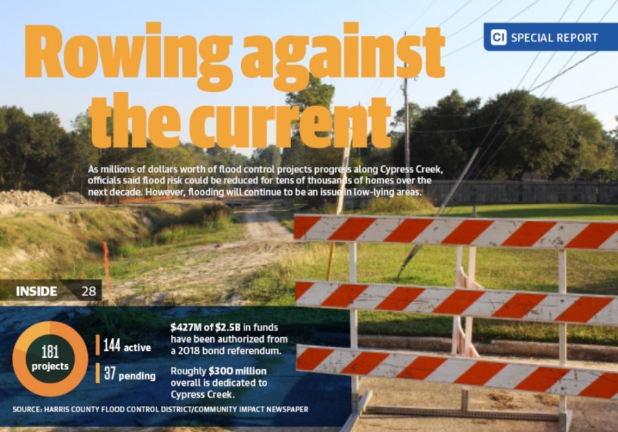
On the heels of the busiest tropical storm season in history in the Gulf of Mexico, Harris County is spending more on flood control along Cypress Creek than it has at any other point in history. While the investment is expected to reduce the likelihood of flooding for thousands of homes over the next decade, experts said flooding will remain a problem for the many homes built in low-lying areas.
The bulk of these efforts took form after voters approved a $2.5 billion bond referendum for the Harris County Flood Control District in 2018, which put roughly $300 million toward Cypress Creek projects.
Flood control officials said plans are coming together for more concrete efforts to mitigate flooding on the creek. Bond projects will be carried out through 2030. Other concepts that are still being studied, such as a proposed underground flood tunnel, would take even longer.
“I think that in Harris County, flooding will always be a risk for people in the Cypress Creek watershed and in all of our watersheds,” HCFCD Deputy Executive Director Matt Zeve said. “But we do feel very strongly that we will be lowering the risk of flooding for tens of thousands of people in the Cypress Creek watershed in the coming decade.”
Despite the investment, Harris County officials, local advocacy groups, and scientific experts all acknowledged that due to how the area was developed over the years, flooding will never be completely solved along Cypress Creek. Meanwhile, climate change is contributing to more hurricanes and storms that produce more rain.
“Will we continue to see storms that are more intense? Yes,” said Stephanie Glenn, program director for hydrology and watersheds at the Houston Advanced Research Center. “But can we continue to plan so that the impacts we see aren’t as intense? I think, as a region, we have the capability to do so.”
From passive to aggressive
More than 8,700 homes flooded along Cypress Creek during Hurricane Harvey, and another 1,700 homes did so during the Tax Day floods of 2016. Some of the more heavily affected neighborhoods in Cy-Fair include Norchester, Ravensway, Enchanted Valley and Lakewood Forest.
When the bond referendum was passed in 2018, the bulk of the $300 million for Cypress Creek was set aside for acquiring land, performing maintenance and building stormwater detention basins in buyout areas.
Late in the summer of this year, plans for detention basins started to emerge when district officials announced they would be taking a more aggressive approach to flood control planning.
The recent developments represent the first time there has been a specific plan for how to address flooding on Cypress Creek, Zeve said.
Decisions on where new detention basins will be built are being guided by a study of Cypress Creek and its tributaries that was completed in February and an ongoing follow-up study. The tributary study also called for channel improvements to parts of the creek where tributaries, such as Faulkey and Pillot gullies, connect. One basin is proposed at Stuebner Airline Road; four are proposed between Hwy. 249 and I-45; and three are proposed downstream of I-45. However, more basins are likely to be proposed. The study also called for a large expansion of a detention basin in Cypress Park near North Eldridge Parkway in Cy-Fair. The cost and timeline have yet to be determined.
Flood control officials said they are looking to add another 25,000 acre-feet of detention along Cypress Creek. Comparatively, about 50,000 acre-feet of detention have been constructed across the county by the district since it was established in 1937, officials said.
“We were able to complete the study, so now, we have a plan, and now, we’re executing the plan,” Zeve said. “We will very aggressively, as much as we can, pursue other funding sources, including our own capital improvement funds, to execute the plan.”
Local advocates, including those from the Cypress Creek Flood Control Coalition, said the move toward building more detention in the watershed is a step in the right direction. Dick Smith, president of the Cypress Creek Flood Control Coalition, lauded the work being done by the flood control district and said he was glad to see the tributaries study updated. However, he said he was concerned about development taking place in the northwestern part of the Cypress Creek watershed near Waller.
The implications could mean worse flooding on Mound Creek and, by extension, Cypress Creek, Smith said. He said he believed Mound Creek was not sufficiently addressed in the study.
“Mound Creek has a potential for, going into the future, an immense amount of water coming down through it,” Smith said. “When you’re talking about Cypress Creek tributaries, that is our biggest concern.”
Although most of the new detention is currently planned to go downstream of Cy-Fair in the Spring and Klein area, Jim Robertson a coalition member who also founded the Cypress Creek Greenway initiative said he did not have any issues with the district’s plans so far.
“We don’t have any disagreement with where they are looking,” Robertson said. “They are more into the technical aspect of the benefits.”
Robertson said he hopes new detention ponds are built with recreation and wildlife preservation in mind.
“As we go into the final stage with all these tracts, I just think it’s incumbent on us think a little more carefully about how we work all this together,” he said.
Hard rains coming
As the flood control district set about updating the 2003 tributaries study, Zeve said, engineers took new rainfall data into account that was published in 2019 by the U.S. National Oceanic and Atmospheric Administration. That data, referred to as Atlas 14, showed an increase in rainfall that can be expected in future storm events across the board in Harris County.
For example, under old rainfall tables, a 100-year storm in the Cypress Creek watershed would be estimated to generate 12.4 inches of rain over a 24-hour period. Under the new tables, the same storm would now be estimated to generate 16.3 inches of rain over the same period of time. This increase in rainfall can be tied to warmer temperatures in the Gulf of Mexico, Glenn said.
The number of storms that formed in the Atlantic Ocean during the 2020 season is indicative of what can be expected moving forward, Glenn said. Although the effects of storms on the Houston area were minimal, a total of 31 storms formed in the Gulf since May, the most in the 170 years records have been tracked.
At the same time, the hurricanes themselves are getting more severe, Glenn said.
“The current predictions are more frequent and more intense storms, [which bring] more and bigger flood events,” Glenn said.
What the future holds depends in part on what governments across the world are able to achieve in terms of forming a set of agreed-upon protocols and reducing atmospheric emissions, Glenn said.
After Harvey, the HCFCD brought on John Nielsen-Gammon, a climatologist and professor with Texas A&M University, to study the effects climate change could have on rainfall events in Harris County. Nielsen-Gammon released the results of his study in May, which show that a “robust upward trend in extreme precipitation is present across the southern and southeastern United States.”
“The historic upward trend is very likely to continue with global warming,” Nielsen-Gammon wrote.
The report also found that an event as severe as Harvey was not likely to hit the Houston area a second time in the foreseeable future.
Planning for the future
Officials with the flood control district stressed that the $2.5 billion in bond funding is not nearly enough to address all the needed projects in Harris County. HCFCD Executive Director Russ Poppe has previously told county commissioners at least $30 billion would be needed to fully protect the county against 100-year floods.
A decision on when another bond referendum could be called and how large it could be falls to the five-member Harris County Commissioners Court, which would have to vote in favor of putting a bond before county voters in a future election.
Precinct 4 Commissioner Jack Cagle, who represents parts of Cy-Fair and Spring, has said a second bond is all but inevitable. However, in a Nov. 12 interview, Cagle said it was too early to be talking about a second bond at this point in time.
“I have always said that we need to have a second bond, but before we can go to the public with a second bond, we have to be faithful stewards with the first,” he said.
One potentially pricey concept that could play a major role in the county’s efforts on Cypress Creek is an underground flood tunnel. In 2019, the county completed a study that showed the soil in Harris County is suitable for a flood tunnel, and the county is 75% of the way through a yearlong study that will determine more details about installing a tunnel, including where it might be located.
Zeve said the Cypress Creek corridor is one of the routes being studied.
“The flood control district and our consultants feel like a large-diameter, deep tunnel system could be effective as a flood damage reduction tool in the Cypress Creek watershed,” he said. “So we’re moving that analysis forward, and we hope to have community engagement meetings and have a draft final report out [by] maybe February or March of next year.”
In 2019, Harris County commissioners also adopted a new framework for how flood control projects are prioritized to ensure that lower-income and marginalized neighborhoods are not left behind. The new framework did not have any immediate effects on projects in the Cy-Fair area, as most of them had already been launched, Zeve said.
Cagle said he opposed the new framework because he wanted projects to be evaluated on a purely “worst first” basis, meaning whichever areas flood the worst are first in line for funding regardless of social vulnerability.
Sara Bronin, a native Houstonian, land use and zoning expert, and professor at the University of Connecticut School of Law, commended the efforts to take social vulnerability into account.
“I would say this shift in policy is overdue, and it is just the first attempt to try to reverse decades worth of neglect in distressed neighborhoods,” she said.
Zeve said flood control officials are working to get through projects as quickly as they can, but a number of factors require time, including obtaining federal grant money. Cathy Spies, president of the Enchanted Valley Homeowner’s Association, said the Telge Road community saw flooding in 2015, 2016 and 2017. Three years after Harvey, she said residents still feel uneasy.
“We all hold our breath when thunderstorms are predicted, and many—including me—make sure valuables are in an upper story,” she said.