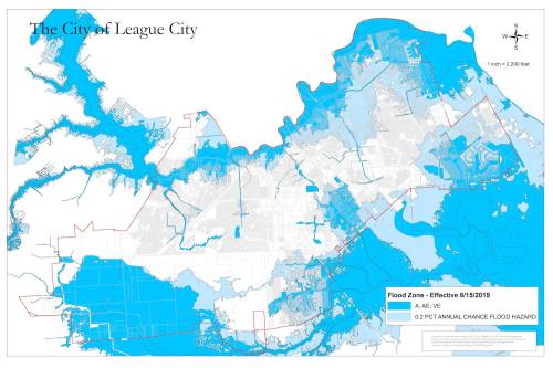
Starting Aug. 15, the Federal Emergency Management Agency's updated flood plain maps will take effect, and thousands of League City homes will be added to the flood plain, affecting insurance rates as well as who is required to get flood insurance.
Under the existing 1999 FEMA flood plain maps, 1,265 League City homes are considered within the 100-year flood plain, which has a 1% chance of flooding during a given year. A total of 4,245 homes are in the 500-year flood plain, which has a 0.2% change of flooding per year.
Under the new maps, updated for the first time in 20 years, 3,730 homes will be in the 100-year flood plain, and 7,378 will be within the 500-year flood plain, an increase of 295% and 174% respectively. About 8,191 acres, or 24.2%, of League City are within the flood plains now, and on Aug. 15, that amount will grow to about 17,097 acres, or 50.4% of the city, according to League City data.
"This is a big change," League City Engineering Director Chris Sims said.
League City City Council in late July voted to adopt the updated FEMA flood plain maps. The city had to adopt the updated maps to remain part of the National Flood Insurance Program, which, in part, provides affordable insurance to property owners.
Any League City resident within the new 100-year flood plain who is still paying a mortgage or otherwise does not own their property must get flood insurance. City officials "strongly recommend" those who do own their homes to still get flood insurance, Sims said.
League City residents might see flood insurance rate increases when the updated maps become official Aug. 15, Sims said.
League City residents can use
this online tool to see if their homes fall within the 100-year flood plain. For more information, visit
League City's flood plain webpage.


