
The $20.2 million study, which began in 2015, is a partnership between the U.S. Army Corps of Engeineers and the Texas General Land Office to identify and recommend projects to protect the entire Texas Gulf Coast and its communities and businesses from damage during tropic storms and hurricanes, Col. Tim Vail said.
"There’s definitely a sense of urgency," he said, noting that the recent hurricane season was one of the busiest in years. “We’ve had some very close calls.”
Originally, officials proposed building a massive navigable gate between Galveston Island and Bolivar Peninsula. The 1,200-foot-wide gate would have closed during storms to hold back storm surge but remained open at all other times to allow ships into and out of the Houston Ship Channel.
Additionally, the original plan, proposed in 2018, included building levee and floodwall segments parallel to FM 3005 on Galveston Island and Hwy. 87 on Bolivar Peninsula.
Due to public feedback, both of these ideas changed between 2018 and the release of the most recent proposed plan, officials said.
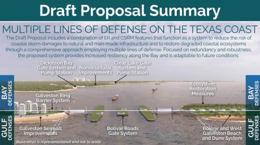
Now, the proposal is to have two large sector gates between three artificial islands that would be constructed between Galveston Island and Bolivar Peninsula. These gates would swing closed from their dry docks during storms and be pumped full of water to sink into the bay. After the storm passed, the water would be pumped out of the gates, and they would swing back into their dry docks, according to a prerecorded presentation from the Corps and GLO.
Two gates assure redundancy and reduce environmental impacts compared to a larger single gate, according to the presentation.
On the outer sides of the two outermost artificial islands, a total of two small sector gates would be built to allow smaller boats in and out of the bay and gulf. Adjacent to them, a series of 15 vertical lift gates, each one about 300 feet wide, would be installed. They would be able to lower into the water in the event of a storm.
To the north, where the water is 5 feet deep or less, about 1,500 feet worth of shallow environmental gates would be installed along with a road to give maintenance crews access to its length.
In all, the four different types of gates would work together to protect the about 7,500-foot channel between the island and peninsula.
Additionally, instead of building miles of levees and floodwalls, the Corps and GLO are now proposing to build a series of beaches and sand dunes to protect the coast—particularly the west side of Galveston Island and the peninsula. A total of 39 million cubic yards of sand—17 million for Galveston and 22 million for Bolivar Peninsula—would be required to build the beaches and dunes, according to the presentation.
Contractors would build beaches 250 feet back from the water's edge and then build two dunes totaling 185 feet wide—a 12-foot-high dune and a 14-foot-high dune behind it. All 58 existing pedestrian access points to coastal beaches would have walkways installed so residents could walk over the dunes. The dune option is more environmentally and socially acceptable than floodwalls, according to the presentation.
Other changes include adjustments to the 15-mile Galveston ring barrier system—a series of walls, gates, levees and pumps surrounding the back side of the island to protect it from flooding—and other adjustments. Some residents may think gathering public comment is a way for officials to "check the box" that they engaged with residents on proposed projects, but the major changes in the Coastal Texas Study are proof residents were listened to, said Mark Havens, GLO chief clerk and deputy land commissioner.
"We’re here today to say: We heard you," he said. "There have been numerous changes to this study.”
The plan has other components besides the gate system, dunes and ring barrier.
The existing Galveston seawall would be improved. A gate system with pumps would be built between Galveston Bay and Clear Lake and the bay and Dickinson Bay, both at Hwy. 146, as a second line of defense from coastal flooding. About 1,750 residences along the bay in various cities, such as Seabrook and La Porte, would be elevated to minimize flood risk, and ecosystem restoration efforts would be made up and down the coast, according to the presentation.
All told, the projects proposed in the study total $26.2 billion: $17.6 billion for gulf defense, $5.9 billion for bay defense and $2.7 billion for ecosystem restoration. However, this is comparable to the cost of storm recovery efforts; it cost $38 billion for the coast to recover from Hurricane Ike in 2008 and $18.5 billion to recover from Hurricane Rita in 2005, according to the presentation.
If the proposed projects are constructed, they would result in about $2.3 billion in equivalent annual benefits. During a 100-year storm, there would be about a 77% reduction in damaged structures and about a 66% reduction in flooded critical infrastructure, according to the presentation.
The study's proposed projects includes several components all working in tandem to offer "multiple lines of defense" for the coast and its residents and industries, including oil and gas, medical, aerospace and more. The need to protect the coast will grow, as experts expect wind and storm surge to grow more severe as ocean levels rise and continue to warm, which will result in more frequent flooding, according to the presentation.
The study team will continue to accept public comments through Dec. 14. To submit comments on the project, email [email protected]; call 409-766-3004; or mail to Attn: Mr. Jeff Pinsky, Environmental Compliance Branch, Regional Planning and Environmental Center, P.O. Box 1229, Galveston, TX 77553-1229.
Comments will be reviewed and considered as the plan is refined, and a final report will be published in May 2021. The chief of the Corps will sign the plan in June, after which it will go before the U.S. Congress for funding, the presentation noted.
Experts are confident the plan is "truly competitive" for federal investment, Vail said.
If funded, the projects would be constructed over 12-20 years, and local sponsors not yet determined would help maintain the projects, such as the dunes.
Public virtual meetings on the project will be held Nov. 16, 6-8 p.m.; Dec. 3, 11 a.m.-1 p.m. and 6-8 p.m.; and Dec. 8, 11 a.m.-1 p.m. and 6-8 p.m. A virtual question and answer session on the project will be held Dec. 2, 6-8 p.m.
For meeting details, visit www.coastalstudy.texas.gov/get-involved/public-meetings/index.html.