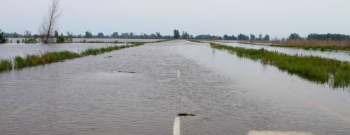
The city of Katy has initiated the final step of its three-phase plan to better handle drainage in the aftermath of April’s flooding.
Katy City Council approved a resolution at its Dec. 12 meeting for Costello Inc.—a local engineering and surveying company—to conduct a flood protection planning study for the roughly 24.7-mile Cane Island Branch watershed. The city will pay Costello an estimated $203,000 through drainage bonds and fees.
City Administrator Byron Hebert said the flood protection study could take up to eight months to complete.
 “It’s not just the water that’s in the city of Katy we have to worry about,” Hebert said. “It’s a lot of the Katy prairie that drains towards us that’s outside of the city. So, they’re not only going to be doing studies inside our city limits, but I’ve asked them to also study the areas that are outside and then try to come up with some type of emergency system.”
The study is the last phase of the city’s three-pronged approach to addressing drainage issues following the Cane Island Branch watershed experiencing what Hebert called a “500-year flood”—or 15 inches of rain in a 24-hour period between April 18 and 19.
The first step was the city’s Public Works Department cleaning up debris, and the second step is enforcing building codes wherein new homes are built higher out of the flood plain, Hebert said.
According to Hebert, about 110 homes out of roughly 5,200 single-family residences in the city of Katy flooded in the April rain event. No homes built after 1998 flooded, he said.
“Though the number is small, even flooding one house is obviously important to us,” Hebert said. “We want to definitely take this opportunity since we got water marks to see what happened and how it happened.”