
Officials with the Houston Public Works Department released more details Aug. 6 on a $198 million project meant to help reduce flood damage in Downtown Houston and along stretches of White Oak and Buffalo bayous.
Details on the project were presented at an Aug. 6 open house.
The background
The concept for the channel originated from the 1980s, said Kevin Hammond, a supervising engineering with the city of Houston who spoke at the Aug. 6 open house. After Hurricane Harvey in 2017, the city received $2.3 billion in disaster relief funding from the Federal Emergency Management Agency, and the Texas Department of Emergency Management later provided a subgrant from that funding for a preliminary engineering report for the North Canal.
During the design phase, Hammond said officials looked at different alternatives for how to move forward with a project that could reduce major flooding around the confluence of White Oak and Buffalo bayous, as well as upstream of both of those bayou and Little White Oak Bayou.
“This purpose grows out of the realization in this area that floods have become more frequent and more severe, especially since 2015,” said Jeff Mitchell, a senior structural engineering with HDR Engineering, the firm contracted by the city of Houston for design work. “That vision for the North Canal is the central piece of this project.”
What emerged was a recommendation for a flat-bottom canal connecting White Oak Bayou with Buffalo Bayou just north of Downtown Houston, referred to at the North Canal. In addition, plans call for White Oak Bayou channel widening just west of Studemont Street near I-10.
Also of note
A third component of the project referred to as the South Canal is also in the preliminary design on the south side of Buffalo Bayou near I-69. However, Hammond said this element has to be completed in coordination with a Texas Department of Transportation Project to widen I-45. TxDOT is leading design and constructing of that element.
The cost
The federal funding for the project will cover roughly $46.1 million of the $198 million cost. The city of Houston is leading the local effort, with additional funding helping coming from the Memorial Heights Redevelopment Authority, the Harris County Flood Control District and TxDOT.
The federal share total is currently around $46.1 million, while local commitments total $85 million, according to HPW officials. However, funding commitments for the updated $198 million cost are to be determined, and project organizers are working to secure additional federal and state funding.
The details
North Canal: The canal will be built as a 60-foot-wide wet-bottom channel that would go above existing underground sewer facilities.
The new channel will cross North San Jacinto Street, where a new bridge will also be built. At that bridge crossing, the canal, including vegetative slopes, would span about 185 feet in width.
Toward the end of the preliminary design review process, Mitchell said the project footprint was shifted by about 60 feet. The proposed path runs over a paid parking lot on San Jacinto Street and property owned by the Metropolitan Transit Authority of Harris County on McKee Street.
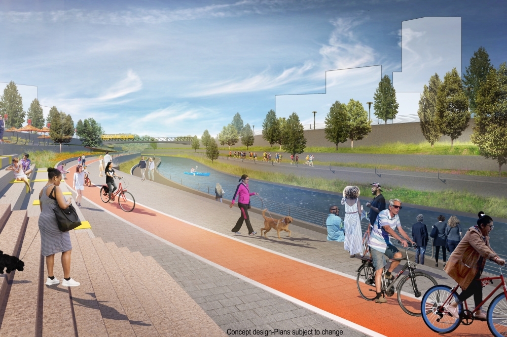
Mitchell said teams are working closely with the Buffalo Bayou Partnership on pedestrian access, including how maintenance paths could also be used to enhance pedestrian connectivity.
Channel widening: The channel widening upstream of White Oak Bayou will help extend the benefits of the North Canal, Mitchell said. Improvements target existing channels at Yale Street and Heights Boulevard that were built in the 1960s, where water flow can get choke off water flow.
Part of the new design calls for building vertical walls that vary from 14-15 feet, which will replace the existing inclined slope. The existing 10-foot-wide White Oak Bayou Greenway trail will be maintained, and new protective railings will be installed to separate the path from the vertical wall leading to the channel.
South Canal: TxDOT's I-45 widening project, also known as the North Houston Highway Improvement Project, is being carried out in phases, and work is not scheduled to begin on the phase affecting the South Canal until 2027. TxDOT is also funding the South Canal, though Mitchell said city officials will coordinate with TxDOT on plans.
With the North Canal creating the potential for increased flow of stormwater, the South Canal is critical to make sure storm water is able to travel downstream, Mitchell said. An area along the South Canal near Buffalo Bayou will be turned into a basin.
An ongoing hydraulic analysis will provide a better picture of the need for more capacity downstream, Mitchell said. As the analysis continues, officials will consider whether more property needs to be acquired to better handle the potential increase in storm water flowing downstream, he said.
Past analyses of the hydraulic benefits from 2022 found the North Canal and the Yale/Heights channel improvements combined for a surface elevation reduction of about 1.26 feet at the White Oak and Buffalo bayou confluence. The addition of the South Canal added another 1.2 feet to the benefit.
What readers should know
Mitchell said two more open houses will take place as an environmental assessment progresses, though dates have not been set.
HPW will accept public comments on the project with a Sept. 5 deadline for inclusion in a draft environmental assessment. Comments can be submitted online here.
The environmental assessment, still underway, is meant to determine whether a project will have significant environmental or social impacts.
Final design is slated for completion in late 2025. Construction could begin in the fall of 2026 and run through late 2029.