Block has lived on 11 acres of land in McKinney’s extraterritorial jurisdiction for over a decade. Roughly half of her property could be obtained by right-of-way acquisition as part of the Texas Department of Transportation’s roughly 15-mile freeway planned for north McKinney.
TxDOT officials conducted a public hearing period for the project’s environmental impact statement from January-April, with both virtual and in-person opportunities for the public to provide feedback.
Following this period, TxDOT officials will continue with further analysis of the alignments along with considering the public feedback, TxDOT Public Information Officer Madison Schein said.
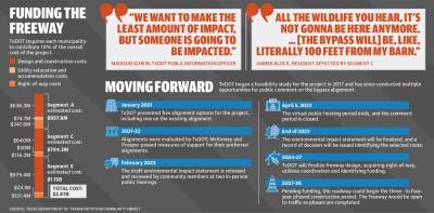
A record of decision, which will finalize the route for the bypass, is expected to be released by the end of 2023. If project funding is secured, construction could begin as soon as 2027.
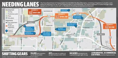
TxDOT has identified the Blue Alternative as its preferred route, consisting of Segments A, C and E. McKinney officials and community members prefer routes that incorporate various segments that have been presented.
The project began in 2016 when the Collin County Commissioners Court determined additional freeway infrastructure was needed in the area, according to Collin County Director of Engineering Clarence Daugherty.
The region’s growth was a primary factor in determining the need for the bypass, Daugherty said. Between 2010 and 2020, Collin County grew by about 36% to over 1 million residents, according to the U.S. Census Bureau.
The court presented the project to TxDOT, which moved forward with a feasibility study on the project in 2017, Daugherty said.
“It’s something that we should have really worked on 10, 20 years ago,” he said of the proposed freeway.
TxDOT officials have since considered the project along US 380, including portions spanning well outside of McKinney’s borders.
“We’re looking at this as a regional picture; we’re trying to go from Denton to Greenville,” Schein said.
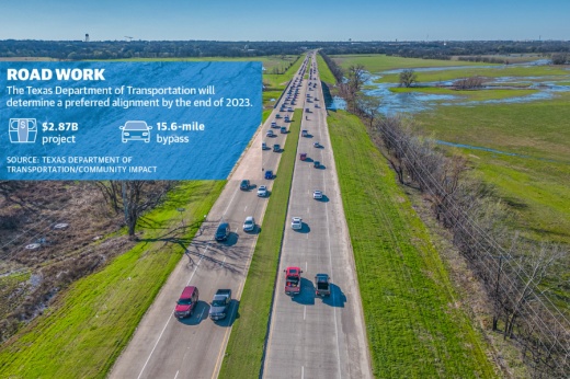
The bypass would consist of an eight-lane, controlled-access freeway with two-lane frontage roads in each direction. The width and number of lanes is determined by projected traffic demand and would require an average of 420 feet of right-of-way, according to TxDOT officials.
“One advantage [of a controlled-access highway] is there is an opportunity for higher speeds, a safer opportunity to navigate traffic through the area and more,” said Travis Campbell, TxDOT’s director of transportation planning and development.
Bypassing congestion
An April 2020 feasibility study from TxDOT identified the growth in central Collin County, including growth in the city of McKinney, has caused increased congestion on US 380.
TxDOT has also ranked the Collin County portion of US 380 from Coit Road to FM 1827 at its lowest level of service, meaning the road has unstable traffic flow and significant delays.
“There must be a [US] 380 bypass. ... Our thoroughfare congestion right now is untenable,” McKinney Mayor George Fuller said.
Traffic congestion in fast-growing Collin County is only expected to get worse. By 2050, an average of 89,100 daily vehicles are expected to travel US 380 on the east side of US 75, according to TxDOT. The west side is expected to see an additional 114,400 daily vehicles. Comparatively, US 380 saw a daily average of 87,500 cars traveling on both sides of US 75 in 2017.
This increased congestion is tied to the county’s anticipated growth. In 2020, Collin County had 1.06 million residents. By 2050, the number of Collin County residents is expected to more than double to 2.46 million, according to TxDOT.
Following the completion of the feasibility study, there have been various potential alignments presented, both from TxDOT and affected cities. Recent plans have identified two western and two eastern alignment options. The east-west portion that will run parallel to existing US 380, entitled Segment E, will connect the selected eastern and western alignments.
The alignment that TxDOT identified as its preferred bypass alignment in a draft environmental impact statement is referred to as the Blue Alternative and consists of Segments A, C and E. This alignment is estimated to cost about $2.87 billion, according to TxDOT documents.
This alignment will potentially affect or displace 35 businesses and 22 residential properties.
“We want to make the least amount of impact, but someone is going to be impacted,” Schein said.
Western segments
The western segment of the bypass consists of two options: Segment A and Segment B. In 2020, McKinney officials expressed support for Segment B, a more gradual connection from existing US 380 to Segment E that is routed through Prosper.
Prosper officials preferred Segment A, a more direct route from existing US 380 to Segment E that is routed through McKinney. Prosper opposes Segment B due to its conflict with the town’s existing master thoroughfare plan and potential effects to existing and future development, according to the town’s website.
“The town of Prosper continues to support TxDOT’s preferred ‘Blue Alignment’ and encourages swift action to alleviate the traffic congestion on US 380,” Prosper Mayor David Bristol said in a statement.
McKinney officials’ preference for Segment B was motivated by it affecting fewer properties and having fewer environmental effects, McKinney City Manager Paul Grimes said.
“We have communities like Tucker Hill where this bypass will go right through their front door ... [and then] cut them off from the incorporated area of the city that they’re so much a part of,” Fuller said. “You didn’t have any situation like that in Prosper.”
Segment A is over $150 million more expensive than Segment B, according to TxDOT. Local agencies, including the city of McKinney, are responsible for 10% of the cost of right-of-way acquisition and utility relocation for portions of the project in its jurisdiction, according to a Jan. 24 McKinney City Council meeting.
City officials have already begun working with Collin County to get assistance in funding the portion they are responsible for, Daugherty said.
“They made the decision, so now we’re trying to figure out how best to move forward,” Grimes said.
Grimes also noted the city has begun meeting with elected officials to identify ways to mitigate the expected effects of the identified alignment.
“We are hyper-focused on how ... we mitigate the concerns that we can still mitigate,” Fuller said, noting the potential for additional sound buffers and other barriers.
Eastern segments
Block, who lives along the proposed Segment C route, uses the front pasture of her property for a horse riding arena, which is also used for therapeutic riding.
The pasture is also home to a honey bee farm and is used for hay production, both of which serve as Block’s tax agricultural exemption. The Segment C route would include acquiring this part of her land to construct the freeway, accounting for nearly half of her property, she said.
“It’s so peaceful out here,” Block said. “All the wildlife you hear, it’s not gonna be here anymore. ... [The bypass will] be, like, literally 100 feet from my barn.”
Block is one of many residents in the area who live on what she called “ranchettes.” Many community members keep bee farms, horses and other livestock on their land.
Many of these residents have voiced their opposition to Segment C at the recent public hearings. Comments will be accepted online through April 5. Segment C affects 10 residences and 19 businesses, according to TxDOT.
“The [Segment] C alignment aligns with [future Spur 399], so we think it ends up being a better interchange,” McKinney Director of Engineering Gary Graham said.
Segment C was included in McKinney’s preferred alignment because of its potential to activate the McKinney National Airport through an intersection of the bypass at FM 1827 and US 380, Grimes said.
Graham also cited the increased cost of Segment D as a reason for the city’s preferred alignment.
“Instead of decimating [forested areas] and then taking out so many of those impacted properties, we believe that TxDOT should look at an alternate route,” Fuller said.
This proposed route would be a hybrid of Segments C and D that would ideally minimize residential displacements, as well as ecological impact, while also still connecting to Spur 399 on the east side of the airport, according to Fuller.
“Whether that’s possible at this point or not, I don’t know, but we are internally identifying what we think is a plausible route, and we will be supplying that to TxDOT,” Fuller said.


