Over the past few months, leaders from Dallas’ Planning & Urban Design Department have been hosting workshop meetings across different parts of the city seeking input on the update to the ForwardDallas Comprehensive Land Use Plan, which will help guide future development in the city.
“This is our guiding document on the next phase of how our city grows... land-use-wise,” Blackmon said.
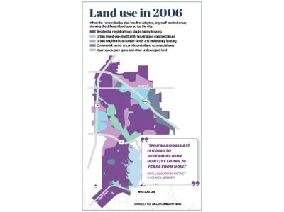
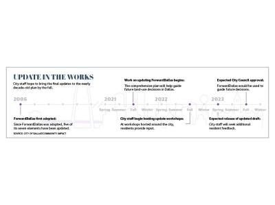
The initial ForwardDallas plan was adopted in 2006 with input from more than 2,000 residents and a goal of being a document that would make recommendations on things like land use, economic development, housing and transportation. The initial plan contained seven policy sections, called elements, to touch on those topics. In that time, five of those elements have been updated through the adoption of other, more specific policies, leaving only the land-use element and the urban design element as the remaining two in need of an update.
“We’ve got a lot of communities that we've known for a while we need to have a review of their zoning,” said Andrea Gilles, assistant director of the Planning & Urban Design Department. “This land-use plan will help us do that and will help us streamline that process.”
Also in the nearly a decade since the initial adoption of ForwardDallas, the population of Dallas has grown from more than 1.17 million to nearly 1.33 million, which has aided in the increase of the average home price from nearly $195,700 2006 to more than $423,000 last year, according to Texas A&M University’s Texas Real Estate Research Center.
With the update to the plan, which Lawrence Agu III, chief planner at the Planning & Urban Design Department, said is meant to be more strategic from a land-use perspective, the city is seeking to specify what each parcel of land could look like and drive future zoning decisions, ultimately helping to determine what Dallas’ neighborhoods will look and feel like in the future.
“Having a land-use plan... affords predictability for the residents and developers,” Agu said. “When the residents know what kind of development is going to happen in their community, they are usually more at ease in terms of what's going to happen.”
Development and preservation
Across the city, Agu said some of the main themes from feedback they’ve received through meetings that have been held so far include connectivity and mobility, housing choice, community design, environmental quality and economic development.
Blackmon and District 14 Dallas City Council Member Paul Ridley, who says his district saw the greatest population increase on the 2020 census and contains the most historic districts, said better connectivity to economic hubs and parks, along with maintaining the existing character of their districts were main areas of feedback they have heard from their residents.
“The community wants to preserve what they have now, but I think where it makes sense, especially along some corridors, they're willing to explore a little bit [of density],” Blackmon said.
Blackmon said new development is beginning to push into the outer rings of the city and that density is already increasing in District 9 with projects like those going on along Ferguson Road. She added that balancing the existing character of the area, which consists largely of single-family housing, while addressing areas where it can adapt to the city’s growth, are important to include in the ForwardDallas update. She pointed to places like the commercial corridors along Garland Road, Ferguson Road and Northwest Highway as examples of areas that could accommodate more density in the form of mixed-use developments or a more diverse housing stock that still fits into the existing feel of the area.
Due to the existing density of commercial developments and number of historic districts, Ridley said District 14 residents will likely focus on redevelopment of neighborhoods, which likely will include increasing density along major thoroughfares, when providing feedback to the Forward Dallas update.
“I'm less concerned about exactly where we're going to locate a gas station or an office building, than I am that [development] reflects the preferences and desires of our residents and our businesses who also have a stake in this,” Ridley said.
Community input
Beginning in October, the Planning & Urban Design Department has been hosting its workshops hoping that by gathering as much feedback as possible from as many parts of the city as it can, it will be able to create the most equitable plan.
At the meetings, which are still ongoing, city staff discuss details of the plan as it pertains to specific regions of the city and the different place types that currently exist in the area, along with those that could exist there in the future. Place types range from rural residential to urban residential and from neighborhood commercial to urban core. After that, residents are asked to identify on maps the parts of their neighborhoods they would like to stay the same, along with those they would like to see changed in the future and what they would like to see put there.
“Land-use guides zoning decisions, which impact many aspects of daily life,” Ridley said. “This includes whether there are enough housing options where you'd like to live, whether there are viable employment opportunities near you, how long it takes you to get to work or shopping and whether you have access to parks.”
The city of Dallas began expanding east towards White Rock Lake with the annexation of East Dallas in 1889–40 years before the city would adopt its first zoning policy. The city’s limits wouldn’t reach the Audelia area until the 1980s, according to the ForwardDallas’ Existing Conditions Report. The largest type of land-use in the northeast section of the city that encompasses the Lakewood and Lake Highlands areas is transportation, followed by single-family detached housing and public open space, per the report.
Gilles said the ForwardDallas plan adopted in 2006 specifically stated that it was not to be used as a land-use plan, adding that the update will provide more of an implementation component. That will allow it to be a “big-picture” guide for future zoning decisions providing predictability, which Agu says will benefit residents by helping them know which types of developments can be built in their neighborhoods and helping alleviate congestion in the city’s permitting and zoning pipeline by letting developers know what types of proposals fit in different areas.
“[ForwardDallas] is going to determine how our city looks 20 years from now,” Blackmon said.
Gilles said the goal of the land-use update is to create “complete places,” or areas where residents have easy access to amenities like grocery stores, restaurants, schools and parks–something both Blackmon and Ridley said they would like to see more of in their districts.
“I think the pandemic actually allowed more people to realize that they have... poor access to trails,” Blackmon said. “I think people realize I can walk or bike to X, so they want safer passage.”
Driving Dallas’ future
Gilles said the ForwardDallas update comes as the city is growing and zoning cases backlog due to not having a land-use guide to provide vision and predictability, which leads to “piecemeal” developments that do not consider the neighborhood or city as a whole.
Dallas is one of the fastest-growing cities in the country, according to an American Growth Project report, which noted that nearly 100,000 people moved to the area from June 2020 to July 2021. By the 2030s, the population of the Dallas-Fort Worth area is expected to reach more than 10 million, making it the third-largest metro area in the U.S., according to a Rice University report.
“Through this planning effort, we want to be more thoughtful and strategic about where new development goes in the future, so we can respond appropriately with the necessary infrastructure and public resources,” Gilles said.
Through spring, city staff plan to continue to gather feedback on the ForwardDallas update through community meetings and via an online portal where residents can leave area-specific comments. Some of those comments in the Lake Highlands area include requests to develop the Northlake Shopping Center into housing. Comments in the Lakewood area include improving the infrastructure around White Rock Lake.
“We don't necessarily have a long history of land-use planning,” Gilles said. ”We want to make sure that people feel engaged in the process, understand what it means to have a comprehensive plan, understand what the place types mean and give people the space to ask questions and provide us feedback.”
City staff expect to begin to produce a draft map of land-use after wrapping up its initial series of workshops in spring. After that, there will be more feedback meetings with the hope of taking a final draft to City Council for approval in the fall.
The ForwardDallas is not the policy related to land use that is getting updated in the city. Dallas Urban Agriculture Plan, which addresses citywide food access and insecurities, is currently in the process of being updated. Next year, the Dallas Bike Plan, which seeks to provide an implementation strategy for a city bicycle network, is expected to begin the process of being updated. In addition, Dallas Mayor Eric Johnson recently requested the city create an inventory of unused, vacant and underused city-owned land that could potentially be turned into public spaces or affordable housing developments.
“[District 9] has not seen a big, big push in new development in the last 20 years,” Blackmon said. “I think it's because like any city you start in the downtown core and you work out. I think the next phase is to come into the northeast Dallas area.”


