
The big picture
City Council voted in October to consider rolling out the "CityLeap" concept on Austin's arterials—streets with two or more lanes running in each direction. The plan would cover well over 100 miles of city roads.
CityLeap was developed by nonprofit Safe Streets Austin and calls to add either protected bike lanes, or bus lanes plus shared-use paths for pedestrians and cyclists, on busy city corridors with a focus on safety.
“[Austin's arterials are] not even good for their central stated purpose of moving people; when you just have general purpose travel lanes, you actually have a far lower people-moving capacity than if you had dedicated space for transit and walking and biking," said Adam Greenfield, director of advocacy for Safe Streets. "They don’t support local businesses well because the arterials are so unpleasant; people don’t really want to go there, and they don’t want to spend time there. And so they’re just not fit for purpose, and they need an overhaul.”
The proposal targets city-owned right of way only, without involving private property. It also doesn't cover Texas Department of Transportation-managed roads, such as portions of South Congress Avenue and South Lamar and Airport boulevards.
Greenfield said CityLeap came together after officials requested a deep dive into strategies to meet local climate and mobility goals earlier this year. The plan was supported this summer by the resident Urban Transportation Commission.
Council member Paige Ellis, who sponsored the request to formally evaluate CityLeap, said it could support wider efforts to improve local air and water quality, and cut the number of vehicle trips around town.
"There are a lot of people that are trying to get creative with their commutes. Whether they are to work or the grocery store or church, or wherever they’re taking their kids, people are trying new methods, and I’m really excited to be able to support that," Ellis said Oct. 10.
Zooming in
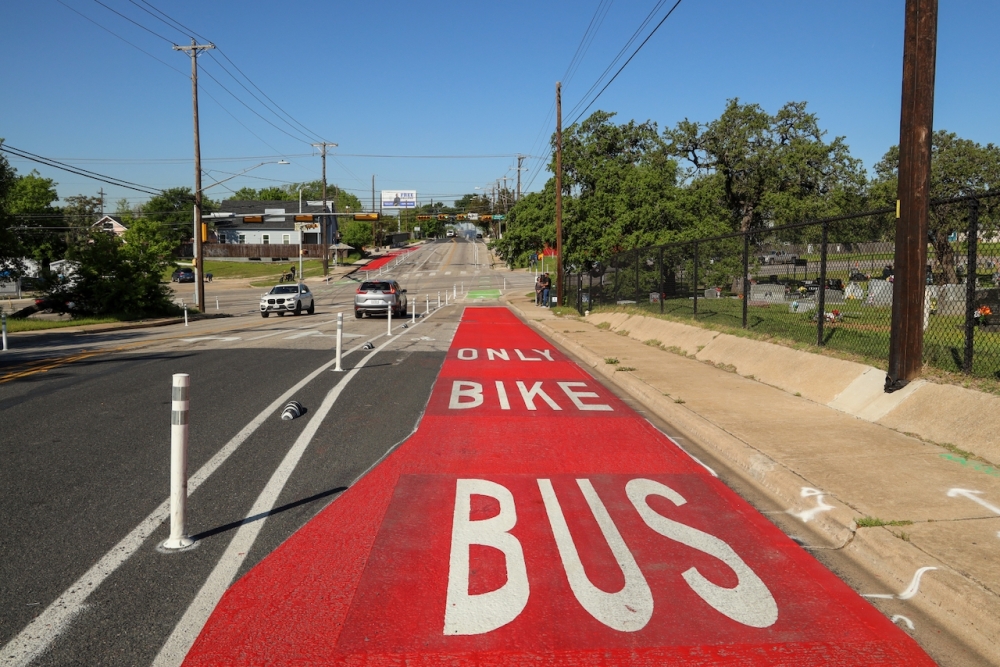
CityLeap could build on similar initiatives that have rolled out both locally and nationwide. In Austin, examples include some safety upgrades under the injury- and death-reduction program Vision Zero, and the recent removal of vehicle lanes over the Longhorn Dam Bridge and on Barton Springs Road.
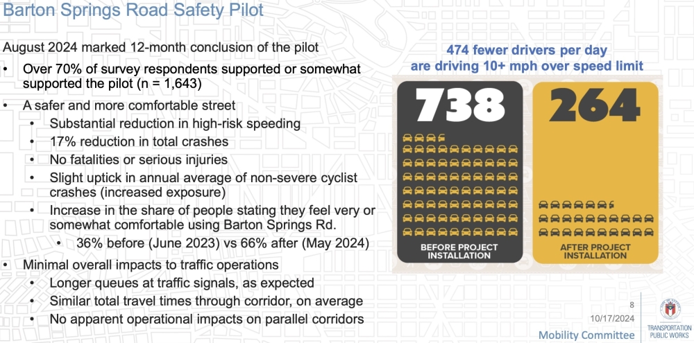
Since starting last summer, the Barton Springs pilot program's first year resulted in slight drops in speeding, crashes and injuries without significant impacts on travel times. Public perception of the changes has also been generally positive, according to city surveys.
"The fact that the city was willing to do that there and confident enough to do that there shows that we are crossing a cultural tipping point that we believe now qualifies us to be ready to take this on across the city," Greenfield said.
Council member Chito Vela stated his support for the upcoming CityLeap review given recent results with lane conversions and safety improvements in the city.
"Ultimately, we’re not going to be able to tackle our affordability or climate change challenges unless we move away from single vehicle, one person in it driving everywhere all the time," he said. "We’ve got to shift to alternative modes of mobility.”
What's next
After council's October vote, city transportation staff will start the planning study with a review of possible costs and the public right of way needed for any upgrades.
The evaluation will also look at how long it'd take to implement CityLeap, policy tradeoffs under the program, and how it could impact crash costs, vehicle emissions and travel demand trends. The city will aim to line up any possible roadway upgrades with local transit agencies' plans as well.
No funding is assigned for CityLeap at this time, but Safe Streets estimates the program could cost up to $240 million if every city arterial is tackled as proposed. That includes what Greenfield called "quick build" projects—more than $14 million for 140 miles of bus lanes and $34 million for almost 60 miles of two-way protected bike lanes—plus $181 million for 90 miles of newly constructed shared-use pathways.
A final report on the concept is expected next July.