

On the heels of a 2022 report from the University of Houston on land subsidence, a Jan. 12 from the Oklahoma-Texas Water Science Center further outlines land sinking that has occurred in the Greater Houston area, according to information released by the Texas Water Development Board.
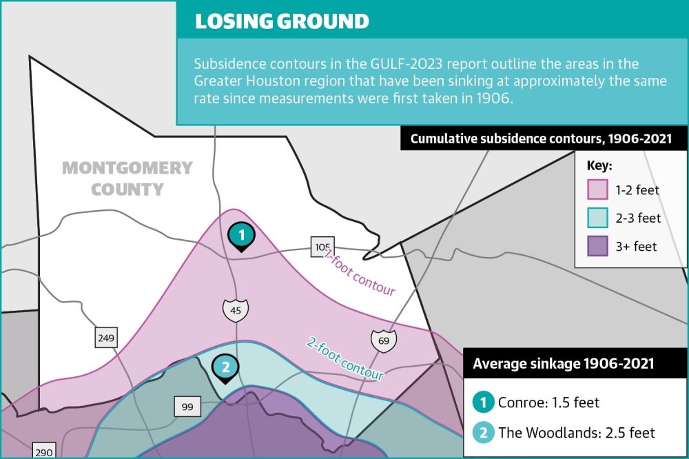
As of 2021, The Woodlands and Conroe saw an average of 2.5 and 1.5 feet of sinking over the past century, according to the Jan. 12 report from the Oklahoma-Texas Water Science Center, with most of the land movement occurring since 1987.
This gradual, vertical decline is known as subsidence, or the sinking of the land due to movement beneath the earth’s surface.
John Ellis—who authored the Jan. 12 study and serves as the center’s gulf coast studies chief—said this subsidence worsens flooding in watersheds by “altering the base flood elevations.”
“[Subsidence] is an important phenomenon to document and to look at and to study because ... it can result in permanent loss of land, increased risk of flooding and the damage to the infrastructure,” Ellis said.
Subsidence is chiefly caused by pumping water from underground reserves, which compacts sublayers of clay and silt in aquifers beneath the Earth’s surface, according to a University of Houston geological study released in August. The resulting sinking is a problem experienced all over the Greater Houston area.
Local entities that govern water in The Woodlands area said in February they are still analyzing what the report means for their understanding of how subsidence is affecting the area.
Jim Spigener, president of the LSGCD board of directors, said at the meeting the agency would try to provide comments within the public comment period before the April 17 deadline.
“We’ve got 90 days to digest it and make our comments on what we agree with, [and what] ought to change,” he said at the meeting. “We have a lot of questions about the model for the [Texas Water Development Board] reps.”
The LSGCD previously has told Community Impact it does not believe the studies place the blame for subsidence squarely on groundwater withdrawl and has questioned methodologies used.
The San Jacinto River Authority, which manages and provides surface water for the region, said the new study provides more accurate information on the subsidence it believes is the result of groundwater withdrawl.
“The Houston region has had one of the most accurate and sophisticated groundwater models in the State of Texas for many decades, and this latest version is no different,” said SJRA General Manager Jace Houston. “This model incorporates the very latest population and water demand data available and has been calibrated using groundwater levels and subsidence data from a broad range of sources. Our Houston-area groundwater models throughout the years have always done a very good job of predicting water-level changes and subsidence, and this latest version will increase the accuracy even more, especially around the edges of the model where data is more recent.”