

Two reports released within the last six months show parts of the Cypress Creek watershed in the Spring area have experienced land displacement, which can worsen flooding and make it more severe.
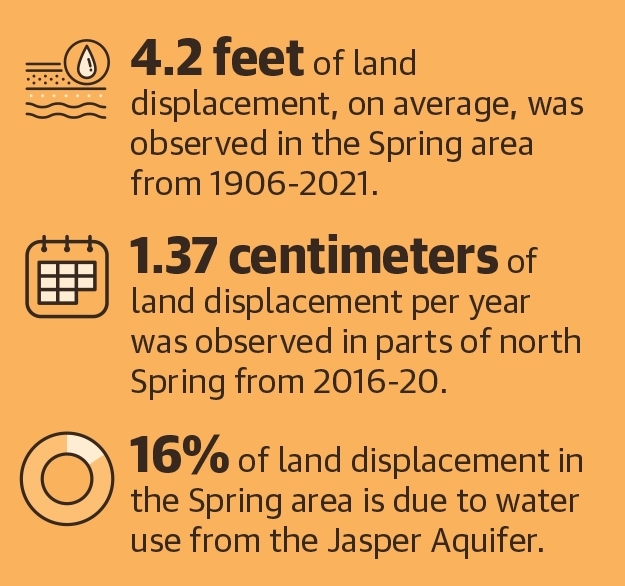
As of 2021, an average of 4.2 feet of land sinking has occurred in Spring over the last century, according to a Jan. 12 U.S. Geological Survey report from the Oklahoma-Texas Water Science Center, with most of the land movement occurring since 1987. Comparatively, The Woodlands and Conroe saw 2.5 and 1.5 feet of sinking, respectively, during the same time period.
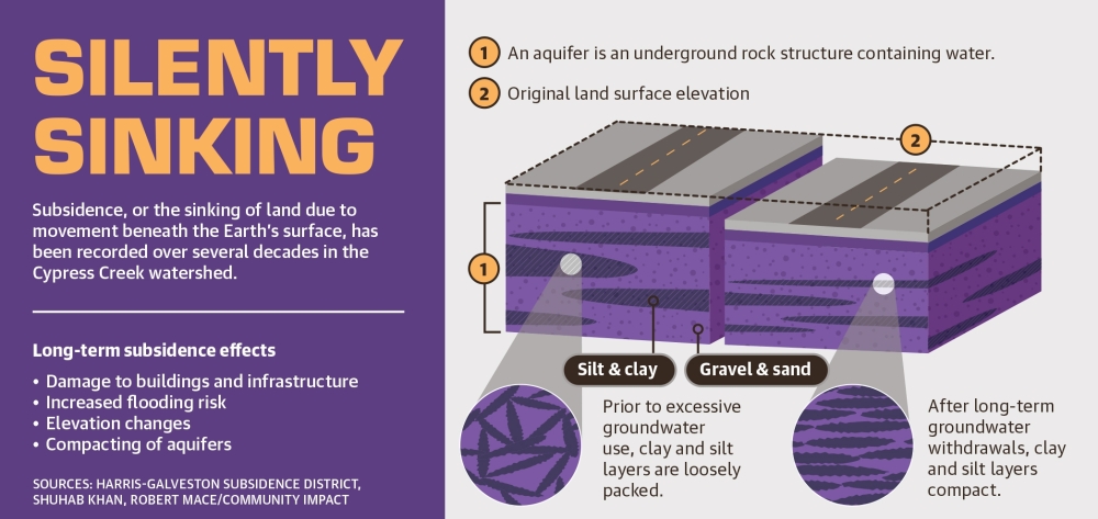
This gradual, vertical decline is known as subsidence, or the sinking of the land due to movement beneath the Earth’s surface.
John Ellis—who authored the Jan. 12 study and serves as the center’s Gulf Coast studies chief—said subsidence worsens flooding in watersheds by “altering the base flood elevations.”
“[Subsidence] is an important phenomenon to document and study ... it can result in permanent loss of land, increased risk of flooding and damage to infrastructure,” Ellis said.
Subsidence is chiefly caused by pumping water from underground reserves, which compacts sublayers of clay and silt in aquifers beneath the Earth’s surface, according to a University of Houston geological study released in August. The resulting sinking is a problem experienced all over the Greater Houston area.
Shuhab Khan, a UH geology professor and one of the August report’s authors, said he believes there is a balance to using groundwater sustainably.
“Groundwater is the cleanest water all over the world,” Khan said. “It is a means for drinking, for agriculture, for industry, and when we start pumping more water than the amount of water that is replenishing [aquifers], that balance is gone.”
The UH study states its findings also imply subsidence may be responsible for fault movement in the Greater Houston area based on analysis of land displacement.
Over time, subsidence can cause damage to property, pipes and roads, Khan said.
To prevent subsidence from worsening, regional organizations are working to decrease groundwater use. Efforts include a $1.4 billion expansion of the Northeast Water Purification Plant in Humble—a joint project between the city of Houston, North Harris County Regional Water Authority, West Harris County Regional Water Authority, North Fort Bend Water Authority and Central Harris County Regional Water Authority.
This plant treats Lake Houston water and turns it into drinking water for parts of Harris County and surrounding areas, including Spring. Upon completion in 2024, he said the plant will increase treated water capacity from 80 million gallons per day to 400 million gallons per day.
NHCRWA leaders were not available for comment as of press time March 8.
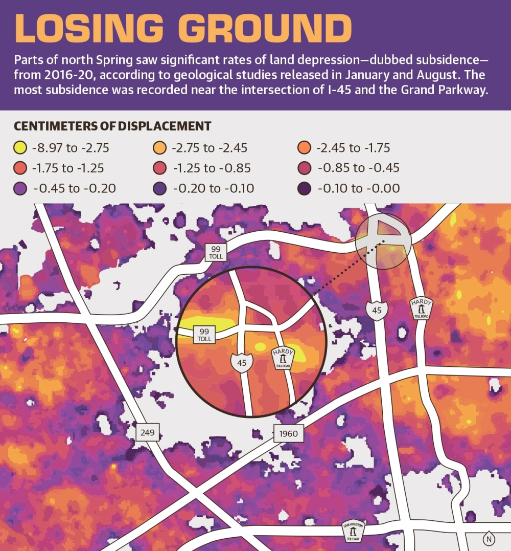
Subsidence in Spring
Land deformation in Houston’s growing suburbs was tracked for the UH study from 2016-21. The results show areas in north Spring—especially near I-45 and the Grand Parkway—saw “rapid, significant subsidence.” According to Khan, any area with more than 2 centimeters of displacement from 2016-20 received this designation.
The UH report also found that the Spring area and northern and northwestern Harris County are experiencing “substantial negative displacement” due to population growth and development as well as the use of groundwater from aquifers. Wells can be drilled into an aquifer—a large, underground water-bearing rock—and water can then be pumped out for residential and industrial use.
According to the USGS report, which covers a new model created to study land displacement and the flow of groundwater from 1897-2018, the Jasper Aquifer accounts for 16% of the subsidence occurring in the Spring area. The aquifer is the lowermost primary aquifer of the larger Gulf Coast Aquifer System, which provides groundwater for much of the Greater Houston area, according to USGS.
Parts of Spring saw among the greatest rates of subsidence in the Greater Houston area from 2016-20, according to UH’s report. These parts of Spring also saw among the fastest rates of sinking. A sinking rate of 1.37 centimeters per year was observed near I-45 and the Grand Parkway from March 2016 to December 2020, according to UH’s report.
Ellis also identified I-45 and FM 1960—near the Cypress Station area—as a subsidence hotspot in the Cypress Creek watershed that showed 5 feet of subsidence from about the 1930s-2021. Ellis said the hotspot near I-45 and the Grand Parkway is experiencing less total subsidence—about 4 feet—than the Cypress Station hotspot because it has not undergone development for as long.
Development leads to more groundwater pumping to meet water needs, said Mike Turco, who is the general manager for the Harris-Galveston Subsidence District, which regulates groundwater and monitors subsidence in Harris and Galveston counties.
“As you add more people, you add more businesses, you’re going to have more needs for water resources, and diversifying those sources from groundwater to an alternative like surface water helps the subsidence issue and prevents subsidence for us,” Turco said.
Data from HGSD shows subsidence has contributed to flooding across the Greater Houston area. However, Turco said a study on the impact of subsidence in the Cypress Creek watershed has not yet been done.
About 70% of water usage in northern Harris County comes from groundwater pumped from the Gulf Coast Aquifer System, according to HGSD. Experts warned excessive groundwater pumping will make flood mitigation more difficult in areas across the Greater Houston area where it is already challenging.
“These [flooding events] are in the same areas where we are seeing subsidence rates at 1 1/2 to 3 centimeters per year,” Turco said.
In addition to worsening flooding, subsidence also contributes to changes in drainage patterns, fault movement, and damages to wells and pipelines, according to the HGSD.
Alternative sources
Although the conditions that cause subsidence can be lessened if residents cut groundwater usage and switch to alternative water sources, the effects of subsidence are permanent, said Robert Mace, water policy director at Texas State University.
“If you reduce your pumping, you can then decrease the maximum subsidence that would have occurred,” he said. “But for the most part, land subsidence is a one-way trip. Once it’s compressed, it’s not coming back up.”
To prevent subsidence from worsening, HGSD set pumping requirements for all water suppliers in Harris and Galveston counties in 2013. The NHCRWA is required under the plan to reduce groundwater usage to no more than 40% of its total water supply by 2025, according to the HGSD’s regulatory plan.
“We expect those subsidence rates to come down to near zero as we implement this plan,” Turco said.