

Every 10 years, a U.S. census is conducted to count each resident in the country. Once completed, state and local governments use the new population data to draw new maps for congressional, state and county representatives. The Texas Legislature wrapped up redistricting for the state in October.
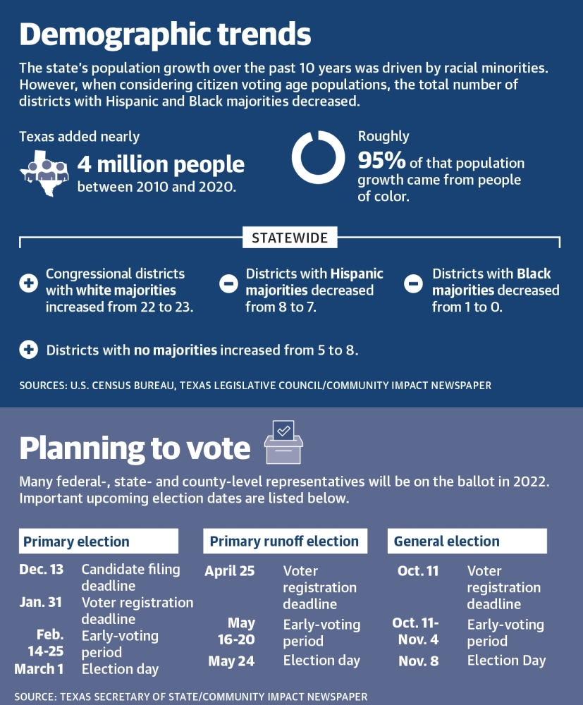
Statewide, two seats were added to the U.S. House of Representatives to accommodate for a roughly 16% population increase over the last 10 years, according to U.S. census data.
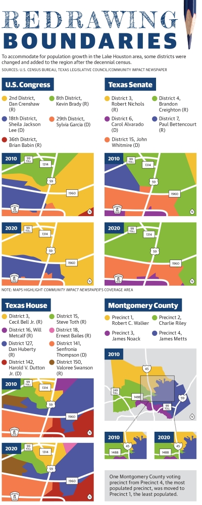
Additionally, the redrawn districts slightly alter congressional representation with more of the Lake Houston area, New Caney, Porter and the southern portion of Montgomery County now included in the 2nd District, covered by U.S. Rep. Dan Crenshaw, R-Houston.
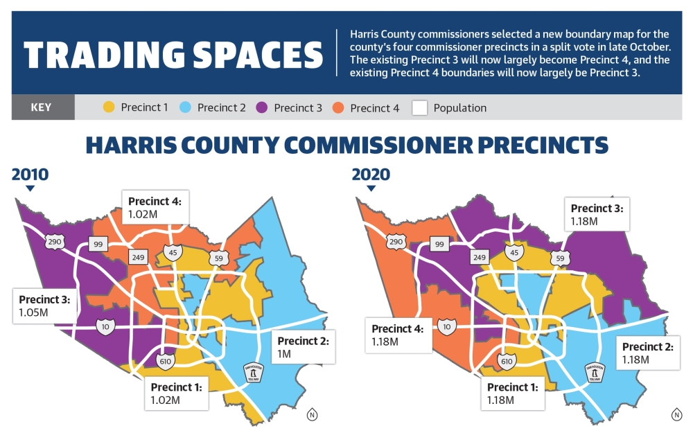
At the county level, Harris County commissioners voted 3-2 along party lines in October to approve a redrawn commissioner precinct map that swapped portions of precincts 3 and 4. Harris County Commissioners Tom Ramsey and Jack Cagle—who represent precincts 3 and 4, respectively—each cast dissenting votes against the new map.
“I thought [the redrawn map] was a joke,” Cagle said at an Oct. 28 meeting. “In essence, you’re taking everybody
that was in Precinct 4, and you crammed them into Precinct 3, and you took everybody that was in Precinct 3, and you crammed them into [Precinct] 4. ... Your people of service are all going to be served by strangers, in terms of flipping all of the resources.”
The redistricting process has already prompted several lawsuits challenging maps drawn both in Harris County and at the state level.
County commissioner precincts
For the past decade, the Lake Houston area fell within precincts 1, 2 and 4. With the exception of an area near the southern tip of Lake Houston that now falls in Precinct 1, communities west of Lake Houston, including Humble and Kingwood, will now be in Precinct 3.
The U.S. Constitution states commissioners court precincts should not deviate from 10% more or less than an ideal population size, which for Harris County was 1.18 million. With the new maps, 2.28 million people—or nearly half of the county—moved.
“The map we passed here today stands in stark contrast to the radical gerrymandering passed in Austin, which was designed ... at the expense of fair representation for all Texans,” said Precinct 1 Commissioner Rodney Ellis, who proposed the approved map.
While the deadline to transition responsibility is not until Jan. 1, 2023, commissioners agreed Nov. 9 to complete the transition by March 31.
In Montgomery County, commissioners unanimously approved a new map that saw boundary changes at the borders of precincts 1 and 4, represented by Robert Walker and James Metts, respectively. Under the new map, Precinct 1 will take over a small portion of the area previously considered Precinct 4.
According to an analysis by law firm Bickerstaff Heath Delgado Acosta, Precinct 1 was the least populous area, while Precinct 4 was the most populous, thus prompting the change.
Both Metts and Walker described the changes as “relatively minor.”
Pending litigation
Cagle and Ramsey joined a lawsuit against Harris County on Nov. 16, which argues the new precinct map violates voters’ right to cast a ballot by forcing constituents in the new Precinct 4 to vote for a new commissioner in 2022 when Cagle’s term is up. Should the lawsuit fail, residents in the new Precinct 3 will not get to vote in a commissioner election for six years.
“You’ve now taken away the right to vote for [1.3] million people. There’s no greater voter suppression than taking away [a resident’s] vote,” Cagle said.
The lawsuit asks the Harris County District Court to draw an interim map for the 2022 commissioner elections while also applying for an injunction to block the map from taking effect.
Gerrymandering—the practice of drawing political districts to benefit a political party or racial or ethnic group—is constitutional, according to Mark Jones, a Rice University political science professor. The practice becomes illegal when redrawn maps hurt the ability of underrepresented minorities to elect a leader that suits them, he said.
Jones said he thought it was unlikely the lawsuit would hold up in court.
“[The lawsuit is] virtually certain to fall on deaf ears and not have any success,” Jones said. “In their case, they don’t even have the claim ... that the maps violate the Voting Rights Act.”
Jones said he believes the new maps will be upheld, which he said could lead to a decline in the quality of services provided by each precinct.
“At least in the short term, you’re likely to have more inefficiencies and a pretty steep learning curve in regard to the maintenance of bridges and roads and the maintenance of public facilities,” Jones said. “I think residents ... can expect some disruption in terms of the quality and provisions of services in the area of parks and recreation and bridges and roads.”
According to Cagle, a court hearing was held Nov. 29 to determine whether a judge would grant a temporary restraining order preventing Harris County from implementing the new map, but the attempt was unsuccessful. An additional hearing on the temporary injunction is slated for Dec. 17—after press time. Cagle said the goal is to get the lawsuit before the Texas Supreme Court by early January.
U.S. congressional changes
The Texas Legislature passed Senate bills 4, 6 and 7 and House Bill 1 on Oct. 19, which drew new district maps for the state Senate, U.S. Congress, State Board of Education and the state House of Representatives, respectively.
The new congressional maps result in New Caney, Porter and some of the Lake Houston area getting new congressional representation. Previously, those areas were included in the 8th District, which was represented by U.S. Rep. Kevin Brady, R-The Woodlands. Now, they fall within the 2nd District, which is represented by Crenshaw.
“I love the communities in my current district and would love to see it stay just as it is,” Brady said. “My congressional district is one of the fastest-growing districts in the nation, and we were overpopulated. We knew the lines had to be adjusted.”
Crenshaw said although the area he represents will change, he thought the interests of his constituents remain largely unaltered.
“While we represented different districts, I believe the interests of our constituents, as with most Texans, are the same,” Crenshaw said.
Gov. Greg Abbott signed the new maps into law Oct. 25, and they will go into effect Jan. 18 with primary elections following in March. However, The U.S. Justice Department filed a lawsuit against Texas on Dec. 6 over the state’s new congressional maps, arguing the plans violate the voting rights of minority voters.
According to the lawsuit, Texas’ population grew by 4 million people over the past decade—95% of whom were nonwhite—and demographic changes within metro-suburban areas over the last 10 years have resulted in more competitive races for incumbent Republicans. The lawsuit argues the state’s new map took those competitive seats off the table by extending them to include more rural and Republican-leaning areas.
State Sen. Joan Huffman, R-Houston, who led the redistricting process, said lawmakers drew the maps “race blind” and they had “not looked at any racial data” throughout the process.
State district changes
The Lake Houston area saw some changes in its state legislative districts with Porter and New Caney now being represented by state Rep. Cecil Bell Jr., R-Magnolia.
State Rep. Dan Huberty, R-Houston, will continue to serve as the area’s representative; state Sen. John Whitmire, D-Houston, will continue to represent Humble and the southern Lake Houston area; and state Sen. Brandon Creighton, R-Conroe, will continue to serve Kingwood and the northern Lake Houston area.
Danica Lloyd, Emily Lincke, Anna Lotz and Darcy Sprague contributed to this report.