
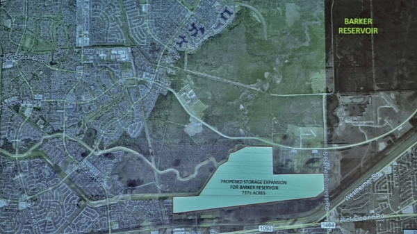
The Willow Fork Drainage District is in the early stages of proposing a new retention pond near the intersection of FM 1093 and FM 1464 inside the Barker Reservoir.
That is according to a presentation by WFDD Director Wendy Duncan—who is also a co-founder of Barker Flood Prevention Advocacy Group, a small-business owner and a Fort Bend County Precinct 3 candidate in the March 3 Republican primary—at the Katy Area Chamber of Commerce Jan. 14 luncheon event.
The WFDD is about 30-60 days away from proposing to the Army Corps of Engineers, which operates the Barker Reservoir, a 200-acre pilot retention pond to store waters during major rain events, WFDD Engineer Craig Kalkomey with LJA Engineering Inc. said at the event.
“[This] is a pilot program that we’re going to present to the Corps,” Duncan said. “We have done our initial agreement to engage with the Corps, but we have not presented this actual idea to the Corp yet. We will do that when we have finished the complete design work. ... This is all just ideas until we actually get approval.”
Duncan provided neither a cost estimate nor timeline for the project.
“This area was identified ... as an area that is not environmentally sensitive,” she said. “It was a rice farming lands and old ranch lands, so it’s a prime spot to dig deeper to provide retention.”
There is more than 700 acres of federally owned land near the intersection of FM 1093 and FM 1464 that has been identified as areas to excavate, Duncan said.
According to the Fort Bend County Appraisal District, the Corps owns more than 2,000 acres near the intersection of FM 1093 and FM 1464.
At the chamber event, Duncan provided other potential solutions to help reduce the risk of flooding in the Katy area. These included:
- developing building standards for new development;
- using home buyouts sparingly;
- desilting channels immediately after a rain event;
- excavating earth to store more rainwater;
- constructing a flood tunnel to convey waters from the reservoir to the Houston Ship channel; and
- containing the Cypress Creek watershed overflow.
Overall, Duncan stressed that a regional approach is needed to pursue flood mitigation solutions. The WFDD—which maintains drainage facilities and parks, including a 4-mile Buffalo Bayou diversion channel and Central Green—is just one of many entities working in the Katy area and the Greater Houston area to improve drainage and reduce flood risk.
“We need infrastructure in this area that will help provide protection for the region,” Duncan said. “The connection between the government and the agencies that actually implement this work and the residents is that we have to share with our government officials that this is important to us.