A historically passive approach to flood mitigation along Cypress Creek could be changing as officials with the Harris County Flood Control District work to roll out a new strategy for implementing projects in the area.
At its core, the Cypress Creek Implementation Program is a watershed-wide approach to planning projects and carrying out projects that are already underway, said Jonathan St. Romain, a project manager with the district. A similar approach is being taken in several other watersheds where projects are underway, he said, including Cedar Bayou and Halls Bayou.
"Before the bond program, we would tackle things at an individual project level," St. Romain said. "Now we're trying to take a more holistic approach. That helps with efficiency, to look at things with a broader view."
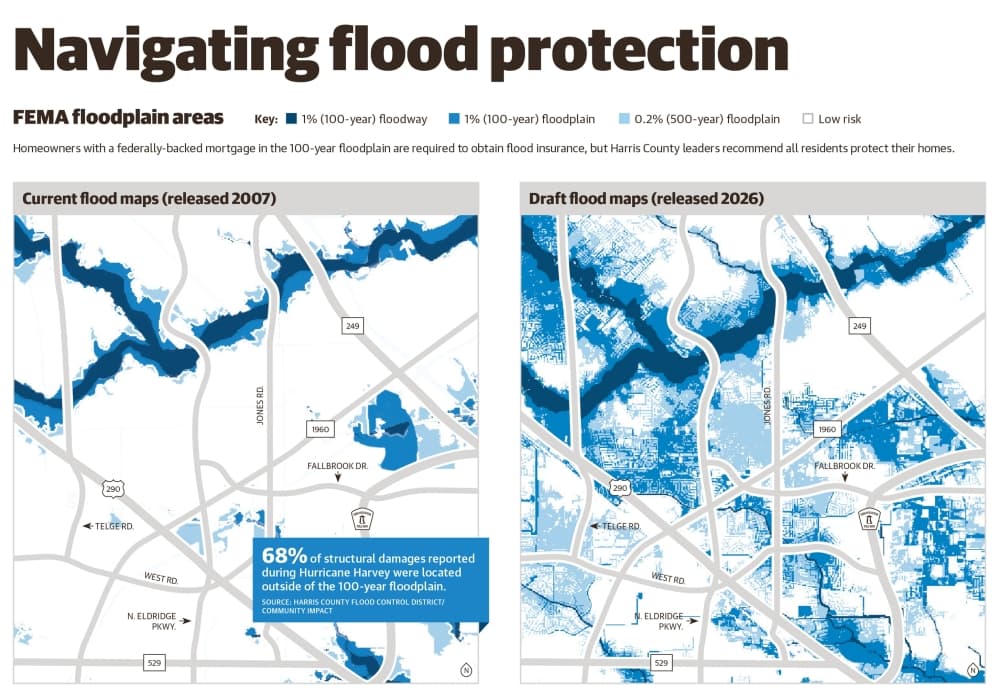
In the past, the district's efforts in Cypress Creek were mostly focused on acquiring land adjacent to Cypress Creek to prevent development, St. Romain said. In a flood control bond referendum passed in 2018 in response to Hurricane Harvey, a little under $300 million in local money was dedicated to projects in the Cypress Creek watershed. The biggest chunk of money—$100 million—was dedicated specifically to right of way acquisition, while the next three largest funding areas were creek maintenance, home buyouts and drainage, which netted $60 million, $47 million and $34 million, respectively.
Although land acquisition efforts have been successful to a degree, St. Romain said the new approach involves using that land for additional flood control measures that could provide regional benefits on a shorter timeline, including detention basins and channel improvements.
A Cypress Creek watershed study updated in February found flooding along Cypress Creek tributaries was predominately caused by stormwater from Cypress Creek backing up into tributaries. This, St. Romain said, indicates that stormwater detention basins on the creek could be a viable way to reduce that flooding.
"The watershed master plan update is sort of the starting point for this implementation plan," he said. "The implementation plan transitions us from this more passive approach of flood plain preservation to a more aggressive approach to actually try to reduce the severity of flooding."
Only one new basin has been officially approved so far and is still in the early stages, St. Romain said, but more are likely to launched. A 171.5-acre basin is in the planning phase at T.C. Jester and Cypress Creek, near Cypresswood Drive, and another potential basin is being investigated east of the Hardy Toll Road, he said. The district is awaiting the results of the grant application before deciding whether to move forward on the latter basin, St. Romain said.
Two other specific sites had their own investigations funded with 2018 bond money: one new basin at Cypress Creek and Steubner Airline Road and one existing basin that could be expanded at Cypress Creek and North Eldridge Parkway. Both projects were recommended for funding in the February tributary study.
"We look at all of the potential properties up along Cypress Creek and essentially develop or build this roadmap for what we can do in the Cypress Creek watershed over the next five, 10, 15 years," St. Romain said.
The TC Jester basin and potential future basins will likely be funded through a mix of flood control district dollars and federal grants, St. Romain said. Read more about the implementation program and find updates on Cypress Creek flood control projects here.