

After being hit by repeated flooding, Cypress Creek has garnered the attention of residents and officials who are pointing to development as a factor in recent storms.
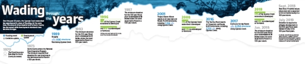
During Hurricane Harvey in August 2017 and the Tax Day flood in April 2016, water from Cypress Creek rose to an elevation of nearly 130 feet and 128 feet, at the respective highest points during each storm, spilling over its banks. Those peaks, the two highest in recorded history of the creek, were measured at a Cypress Creek and Grant Road, according to data from the National Weather Service.
In those storms, 8,750 and 1,735 homes in the Cypress Creek watershed were damaged, respectively.
Estimates from the Houston-Galveston Area Council show the amount of developed land within the watershed increased from about 18% in 1996 to as much as 52% in 2018.
Prior to the two floods, data shows at least 2,199 development permits were issued from 1991-2015 along sections of eight major roads near the creek between Hwy. 249 and Hwy. 290, some of which include Cypresswood Drive and Grant, Telge and Huffmeister roads, according to Harris County Engineering Department data.
Paul Eschenfelder, the founder of Cypress Creek Association—Stop the Flooding, an organization that educates residents about flooding, said he believes development is partially to blame.
“Too much impervious surface gives the water no place to go, no place to stand, no place to soak in,” Eschenfelder said. “For too long, in the interest of ‘economic prosperity,’ we have ignored the flood threat and implemented lax building standards, which favored the developers and builders, at the expense of the long-term occupants on those buildings.”
Meanwhile, Harris County Flood Control District officials said they believe their standards—which include criteria for building in flood plains and creating detention—have kept up to pace with development.
“I don’t think development causes the problems that ... the public thinks it does,” HCFCD Professional Engineer Gary Bezemek said. “I personally have not seen any real supportive data that shows that bayous are significantly impacted because of development, if [developers] are actually [following] the detention policy.”
Development dilemma
The first Flood Insurance Rate Map for Harris County was created in 1970, said Shawn Sturhan, the assistant manager of permits with the county engineering department.
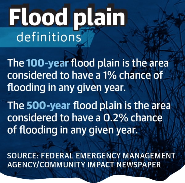
This map identified the county’s floodway—where development is prohibited—as well as the 100-year and 500-year flood plains, where development is allowed but with tighter restrictions.
In 1973, the minimum floor elevation for a new structure built in the 100-year flood plain was set at “base flood elevation”—the level of elevation expected to flood during a 100-year storm. By 1997, the minimum elevation in the 100-year flood plain had been increased to 18 inches above base flood elevation. Despite several Houston-area flooding events taking place since then, development standards would remain the same until after Harvey, according to county records.
In January 2018, Harris County commissioners voted unanimously to increased the minimum elevation to 24 inches above the 500-year flood plain. For the first time, the county also implemented a minimum elevation in the 500-year flood plain, requiring structures to be built to the 500-year storm elevation level.
In July 2019, any development in the 500-year flood plain became required to have enough detention to offset the dirt brought into the site for elevation purposes.
The 2019 standards were based on new rainfall data compiled by the National Oceanic and Atmospheric Administration that showed heavy rainfalls were more likely to occur in Harris County than previously thought, HCFCD Deputy Executive Director Matt Zeve said. Known as Atlas 14, the data showed roughly 18 inches of rainfall can be expected to fall over a 24-hour period during a 100-year event, up from the previous estimate of 13 inches.
However, any development that had been approved at the time the new regulations were adopted would be grandfathered in and would continue to be held to the former standards, officials said.
A Community Impact Newspaper analysis of permits approved on eight roads that cross or run parallel to Cypress Creek showed that of the nearly 2,200 permits issued between 1991-2015, roughly half were issued in the 10 years prior to the 2016 Tax Day flood.
Trusting the models
As a member of the Cypress Creek Flood Control Coalition board of directors and the chairman of the Cypress Creek Greenway Project, Jim Robertson works to bring attention to flooding issues, including the inadequacy of development regulations and the importance of preserving green space. Robertson said his main concerns relate to a regulation that states new development cannot have an “adverse impact” on existing development up or downstream.
“A continuing question is whether or not the existing regulations achieve ‘no adverse impact,’” he said. “Two engineers can have two different interpretations; it’s not always black and white.”
According to Zeve, when a development is proposed the developer hires consulting engineers who complete hydrological and hydraulic studies and submit those results to the HCFCD. Once the HCFCD reviews the submission, the engineer revises the plans before signing off on the project.
After construction begins on the project, the engineering firm is tasked with hiring an inspector to ensure the project is built in accordance with the approved plans. Dick Smith, the president of the Cypress Creek Flood Control Coalition, said he is under the impression the HCFCD does not double-check the modeling once a project is completed, essentially taking the engineers at their word.
“In the world I came out of, you have verification that the purported design is OK in the design phase, and after that you go through the as-built evaluation to confirm it met with the design,” Smith said.
Zeve said following up on every development would require a shift in how the district operates.
“That’s not impossible, but it would take some significant action by Harris County Commissioners Court and a significant money increase to hire literally hundreds and hundreds of inspectors,” he said.
Cause for concern
In the Cy-Fair area, residents in flood-prone communities have expressed concerns about development projects that continue to get approved.
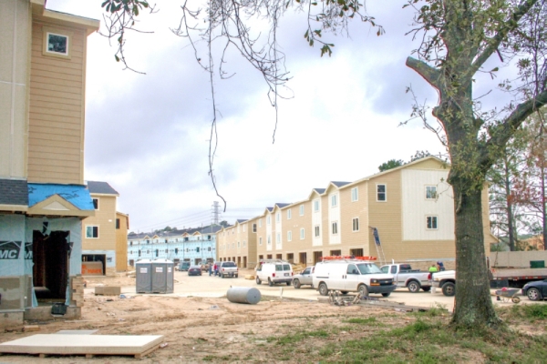
Starwood Farms, a townhome project under construction on 26 acres on Telge Road north of Cypress Creek, elicited concerns from residents when it was first announced in 2018. At that time, Enchanted Valley resident S. Clarke Ohlendorf said he feared the new concrete being poured for the project would direct more flood water into Cypress Creek in a way that would cause worse flooding in Enchanted Valley, which saw flooding during Harvey.
“Once that land is developed and covered with additional concrete it will move more water toward the creek and absorb less,” he said.
Officials with Fourplex Investment Group, the developers behind the project, stressed they were working closely with Harris County. About eight acres of land will be left undeveloped for future creek improvements, and the project will also include a detention pond, officials said. Work on the project is slated to be finished around the mid-2020.
Cypress Bend resident Jason Grubbs said he has concerns about the rapid pace of development in general around Barker Cypress and Telge roads. He said his house in Cypress Bend, which bumps up against the south side of Cypress Creek near Barker Cypress and Jarvis roads, took on two feet of water during Harvey.
“If this land does not take on [the] excess water it has in the past, it will turn everything between it and Barker Cypress into a bowl,” he said.
Several developments are also being planned in the Little Cypress Creek watershed, the waters from which flow downstream into Cypress Creek. The HCFCD maintains stronger development guidelines in that watershed, including a $4,000-per-acre fee to develop. That funding is used by the district to buy land for detention basins.
Among the upcoming developments is a 533-acre residential project by Ersa Grae Corp. that could ultimately plant 1,800 homes near the northwest corner of the Grand Parkway. Residential Project Manager Houman Samanian said the developer is “extremely conscious” of flooding requirements and is working closely with the county to meet the more stringent regulations.
Failing to keep up
Despite changes to Harris County’s flood plain development regulations that were approved last summer, Jill Boullion, the executive director of the Bayou Land Conservancy—a nonprofit that works to preserve land in the Greater Houston area—said she feels the update is not sufficient to keep up with Harris County’s reality.
“Every time there’s a new road, a new residential development, a new commercial development—that’s roofs, that’s parking lots,” she said.
Boullion added her hope would be that Harris County no longer allow development to occur within the 100-year flood plain.
However, Zeve said he believes putting a moratorium on development is not a solution to the flooding crisis. He added that doing so would be a job for state legislators, not the HCFCD.
“Redevelopment’s happening in areas that have already been developed,” he said. “Our job is to make sure when those plans and those drainage studies come in, that they meet our criteria.”
State Rep. Sam Harless, R-Spring, said he is considering introducing legislation that would restrict construction of senior or assisted-living facilities within areas that have previously flooded.
“The connection between development and flooding—I think that is pretty well established,” he said. “For an area without zoning, it is challenging to keep pace with construction of roadways and development while managing the limited watershed areas without negatively impacting someone downstream.”