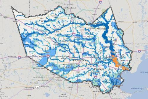
Harris County received a $6.5 million grant from the U.S. Department of Homeland Security in late September that officials said will help fund an effort to remap floodplains throughout the county.
The remapping effort was one of several countywide projects proposed to be funded by a $2.5 billion bond referendum approved by voters on Aug. 25. The project—which will take place over the next five or so years and cost an estimated $25 million in total—is intended to give flood control officials a better idea of where flooding takes place during rainfalls of various severity.
Floodplain maps are also used to determine flood insurance premiums, said Matt Zeve, chief operations officer with the Harris County Flood Control District.
The $6.5 million grant came with the requirement that the county supply $8 million in matching funds. The money will be used to help fund the process of reviewing qualifications from engineering consulting firms, which Zeve said is underway. The firm chosen by the county will ultimately do the heavy lifting with regards to the remapping, Zeve said.
"There’s a lot of technical work that has to be done as part of the remapping effort," he said. "It’s very extensive process to remap an area the size of Harris County, just in terms of square miles ... The funding will help partially pay for that engineering work and surveying."
The HCFCD is one of the few districts in the U.S. that keeps and maintains its own comprehensive models used to locally review to all proposed changes to the floodplain, Zeve said.
"For most communities in the United States, all that goes through FEMA," he said.
Zeve said the county hopes to have all the maps updated by 2023. A previous floodplain remapping effort began in 2001 following Tropical Storm Allison and lasted until 2007. That remapping effort cost $33 million, Zeve said.
"We hope to be a lot more efficient using the lessons learned from the 2001-07 effort," he said.