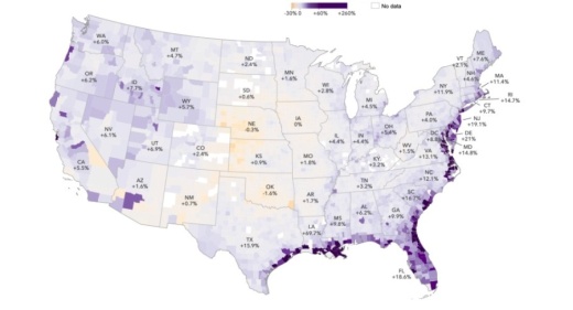
With the new dataset, First Street also unveiled a Flood Factor dashboard that anyone can use to assess the risk of flooding over a 30-year period for any address or city.
The reason for the discrepancy has to do with how the nonprofit incorporated historical data, climate change and forecasting, including drawing on research from over 80 scientists into its risk assessment model, said Ed Kearns, First Street Foundation’s chief data officer.
“In environmental engineering, there is a concept called stationarity, which assumes that today is going to be like yesterday, and tomorrow is going to be like yesterday,” Kearns said in the news release. “This concept used to work, but with a changing environment it’s a poor assumption and no longer does. FEMA’s method assumes stationarity, First Street’s does not.”
The model also serves as the first free, publicly available comprehensive flood risk tool.
“Sophisticated investors have privately purchased flood risk information from for-profit firms for years,” said Matthew Eby, the executive director of First Street Foundation, in the release. “First Street Foundation has not only taken this kind of data to the next level, using peer-reviewed science, but is correcting an asymmetry of information by providing free access to everyday Americans.”
Even more data beyond the public Flood Factor tool will be made available to academics and other partners for further study, the foundation said, and corporations and other groups can pay for access, with revenue going toward future development.
Evaluate flood risks in your city
Here are some of the Flood Factor models for metropolitan areas in Community Impact Newspaper's readership:
- Houston has increasing flood risk, with 202,320 properties at risk in 30 years.
- Austin has increasing flood risk, with 16,522 properties at risk in 30 years.
- Dallas has increasing flood risk, with 22,045 properties at risk in 30 years
- Atlanta has increasing flood risk, with 14,887 properties at risk in 30 years
- Phoenix has decreasing flood risk, with 61,466 properties at risk in 30 years.
- Nashville has an increasing flood risk, with 33,813 properties at risk in 30 years.


