In a nutshell
A collaborative effort among the city of Austin's Urban Trails Program, the city of Sunset Valley and the Hill Country Conservancy, the project was about 10 years in the making.
Funding for the project includes:
- $1.77 million from a Capital Area Metropolitan Planning Organization grant
- $1.2 million from the 2016 mobility bond
- $550,000 from the 2012 bond
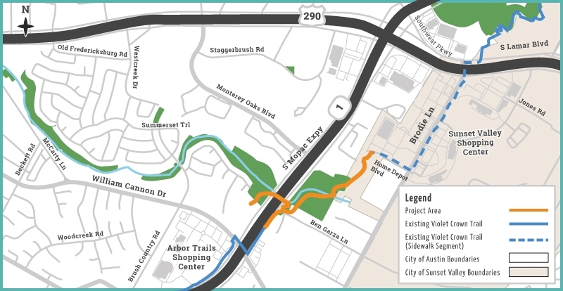
The newly complete 1-mile extension connects Home Depot Boulevard to MoPac just north of William Cannon Drive.

Key features include:
- Americans with Disabilities Act-compliant accessibility
- Generally about 10- to 11-foot-wide paths
- Composed of both concrete and stabilized granite
- An accessible crossing beneath MoPac via a boardwalk adjacent to Williamson Creek
- Connections to nearby sidewalks and existing sections of the Violet Crown Trail
- A new shared-use path on the northbound MoPac service road between Ben Garza Lane and Sabino Lane
The celebration July 29 will include:
- Remarks from elected officials and a ribbon-cutting ceremony at 9:15 a.m.
- Live performances from the Crockett Cougar Band
- Complimentary popsicle treats
- A family-friendly bike ride led by Ghisallo Cycling Initiative
- An interactive nature walk led by Hill Country Conservancy
- Kids projects and activities from The Home Depot
Now that the project is complete, the 30-mile trail system stretches from Zilker Park south through Sunset Valley to the Lady Bird Johnson Wildflower Center, continuing farther south into the countryside of Hays County.
Notable quote
“Hill Country Conservancy is excited to partner with the city of Austin and the city of Sunset Valley to celebrate this beautiful new piece of the Violet Crown Trail,” Hill Country Conservancy CEO Kathy Miller said. “This section of the trail furthers the Violet Crown Trail vision to provide an alternate means of transportation for the community and the opportunity to connect with nature amidst a busy urban area.”
Learn more
Those intending to attend the celebration are encouraged to RSVP for free.
Anyone interested in planning a future trip to the trail can download maps to help better plan their journey.


