
Construction is set to get underway sometime next year on a $13 million project meant to prevent flooding in a vulnerable neighborhood between the San Marcos and Blanco rivers.
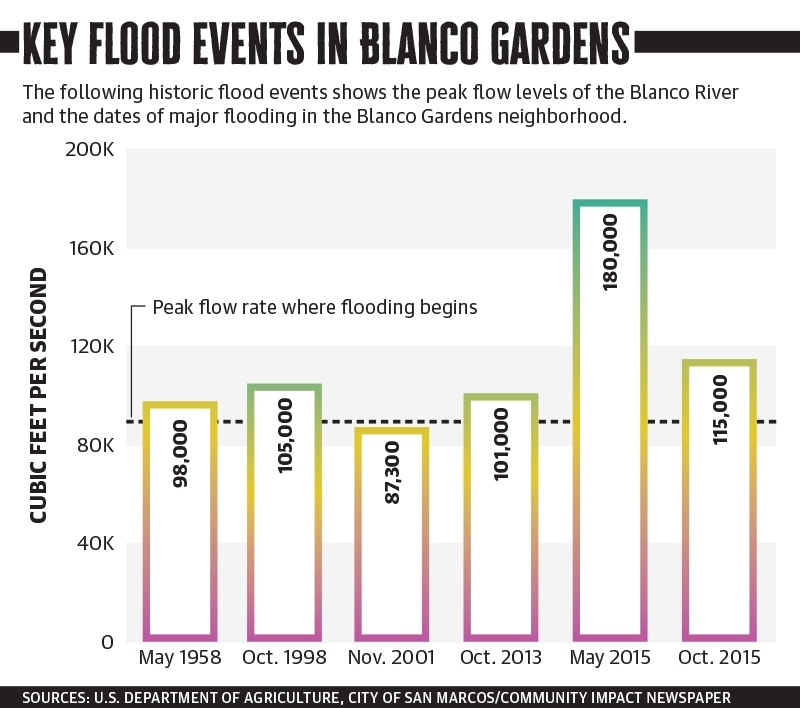
The Blanco Riverine Flood Mitigation Project was prompted after two floods in 2015 that left a good portion of the Blanco Gardens subdivision devastated. One flood that year, on Memorial Day, was a flood of record proportions for San Marcos and the surrounding area and considered a 200-year flood, according to city documents.
The second flood that year on Oct. 30—referred to as the All Saints Day Flood—was considered to be a 50-year flood event.
The Blanco Gardens neighborhood is considered able to handle a 25-year flood event by the city—or an event that has a 4% chance of happening in any given year. There were 1,558 housing units in San Marcos that the city reported sustained flood damage, and of those, 80% were located within that neighborhood.
“The key here is that when the Blanco River floods, at an event over a 25-year frequency, it spills out of its banks and into the Blanco Gardens neighborhood,” said Jacquelyn Thomas, senior engineer with the city’s engineering and capital improvements department.
“Most recently in the 2015 year we had two floods that occurred where the Blanco River spilled out of its banks into the neighborhood” that led to disaster-relief funding for this project, she said.
The U.S. Department of Housing and Urban Development awarded the city $34 million in Community Development Block Grant-Disaster Recovery funds in 2016 for this and other projects. The project is bounded by Hwy. 80, River Road, I-35 and lies between the San Marcos and Blanco Rivers. It will consist of a mix of flood walls and earthen berms, Thomas said. Bidding on the contracts will take place early next year.
“When the river starts to come out of its bank, it flows into the neighborhood ... with the berm and flood wall in place, that water is more controlled and will be sent through the relief channel and end up in the San Marcos River more directly,” Thomas said.
Current conditions mean up to 3 feet of water can end up in the neighborhood, but under the new plans, 1.5 feet of water could end up in the neighborhood and exit more rapidly, and that is in the event of a 100-year flood or worse, she said.
The project was scrutinized under third-party environmental and flood modeling reviews as presented to City Council on Nov. 3. Other surrounding areas of the city are not expected to be affected by the construction or final outcome of the project.
“We determined there are no impacts upstream or downstream related to the project,” Thomas said.