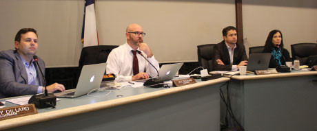
 Rollingwood City Council discusses water pressure problems at its Nov. 18 meeting.[/caption]
Rollingwood City Council voted Oct. 21 to create an updated city water system map and electronic model.
Mayor Thom Farrell said Rollingwood has been experiencing issues stemming from low water pressure in recent months. This purpose of this process is to identify solutions to the water pressure problems, he said.
The project will begin with the Public Works department determining the sizes and locations of water lines, said Marcus Naiser, a project manager with LNV, Inc., the city’s engineering consultant. The engineers will use the data to run an updated, computerized water model through various scenarios to identify deficiencies and recommend improvements, he said.
“[The pressure issues] couldn’t come at a worse time for us,” Farrell said. “We were going through with requesting a revision of [the city’s] fire rating for insurance purposes, and I put that on hold until we get our water pressures stabilized. That’s potentially big savings for our residents if we are able to get a better rating on our fire code, so we really want to try to get this done.”
Fire ratings are partially dependent on the flow rate of water that is available for fighting fire, Farrell said.
Public Works Director Jackie Bob Wright said he has received calls from residents with concerns over low water pressure and others report water pressure that is too high.
“[The water system and valve map] is a decision-making tool,” Naiser said. “It helps you to make decisions in the system as far as what lines to improve and if you need to put in some [additional] valves for the zone.”
Naiser said LNV will determine how large the water pipes need to be in order to support buildings’ fire sprinkler systems of varying square footage.
Farrell said he was concerned the current pipes cannot support fire sprinkler systems in some areas.
“I understand that we need to do this because we have a complex system because of our topography,” he said.
The city’s Public Works Department is collecting pressure data before determining the location of the valves, Naiser said at the Nov. 18 City Council meeting.
Wright estimated it would take 60 days to determine water line locations and sizes and Naiser said an additional 60 days is needed to complete the water system map and model.


