

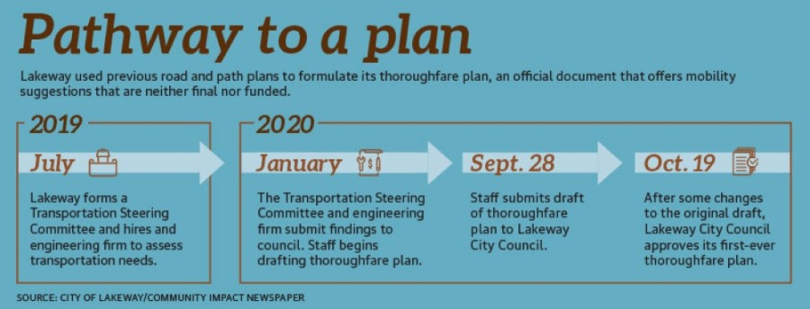
On Oct. 19, Lakeway City Council unanimously approved its first-ever thoroughfare plan, an official city document that presents a long-range plan for the city’s future roadway and pathway development.
“This is a thoroughfare plan that is really focusing on, for long range, how to move traffic and pedestrians safely throughout the city,” City Manager Julie Oakley said when the first draft of the plan was introduced to Lakeway City Council on Sept. 29.
Although it makes specific recommendations for roads and paths, the thoroughfare plan’s recommendations are “conceptual and are not final construction alignments,” according to city documents.
City staff and council members stressed that the thoroughfare plan only includes recommendations that are neither final nor funded.
“This is kind of like a [comprehensive] plan. This is a vision,” Lakeway Mayor Sandy Cox said at the ••Oct. 19 meeting. “It could end up being cost-prohibitive.”
Funding for the thoroughfare plan “will primarily be driven by private development,” according to interim Building Director Erin Carr.
Council members said that when developers approach the city about new projects, city officials can use the plan as an official document that lays out infrastructure improvements that should accompany new development.
“It’s a nonbinding vision, but it gives us a standing to require certain types of trails and roads,” Council Member Steve Smith said. It can also show what private investors could fund to fast track their projects.
“This is a tool that can be used when talking to developers,” Council Member Sanjeev Kumar added.
According to a staff report, the Lakeway Capital Improvement Plan, which funds infrastructure improvements and maintenance, could also help fund parts of the plan. Other potential funding sources include the Texas Department of Transportation, the Capital Area Rural Transportation System, Central Texas Regional Mobility Authority, the Capital Area Metropolitan Planning Organization and Travis County.
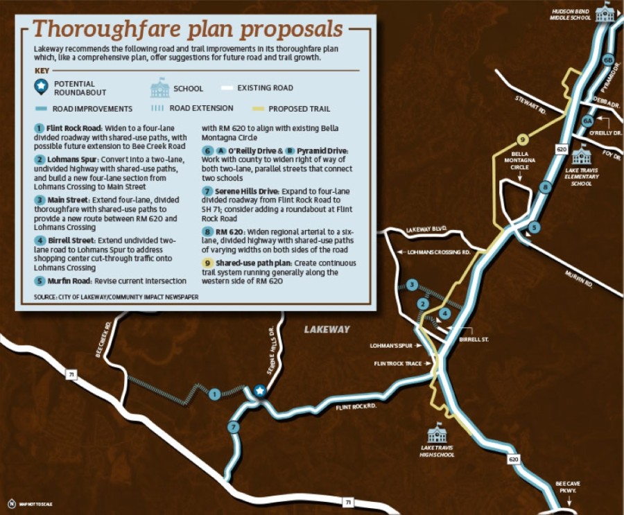
The thoroughfare plan focuses on improving or extending road routes; a continuous, north-south, shared-use path through the eastern part of the city; and the creation of areas for future shared-use paths through the Hamilton Greenbelt and Yaupon Creek residential areas.••Suggested road extensions
In addition to widening and other improvements to existing roads, the plan recommends the extension—and, in one case, the movement—of roads in the city and its ETJ.
Flint Rock Road runs west from RM 620 before dead-ending just west of Fox Creek Estates. Beyond upgrading the existing road, the plan recommends an eventual westward extension of Flint Rock Road to Bee Creek Road as well as a new roundabout at its intersection with Serene Hills Drive.••Lohmans Spur Road connects Flintrock Trace with Lohmans Crossing. The plan recommends improvements to the existing road to make movement safer for pedestrians and bicycles and proposes an extension of the road to Main Street, north of its current terminus at Lohmans Crossing Road.
According to the plan, Main Street, a divided thoroughfare that runs west from RM 620 before ending at Medical Drive, should eventually be extended west until it intersects with Lohmans Crossing Road.
The plan further recommends that Birrell Street, which extends west off RM 620 just south of the U.S. Post Office, eventually be extended to Lohmans Spur to alleviate shopping center traffic on Lohmans Crossing.
Another plan suggestion is that Murfin Road have its intersection with RM 620 moved north to align with Bella Montagna Circle intersection to improve safety.
Some of the ideas for roads in the plan lie outside the city’s limits. In those instances, the plan recommends coordinating with Travis County.
Pedestrian facilities
The pedestrian facilities plan, which is included in the thoroughfare plan, offers recommendations for the locations of future sidewalks, recreational paths and off-street trails to provide a pedestrian system “connecting residential areas with recreational, educational and commercial areas,” according to planning documents.
The plan calls for a continuous, shared-use path running north-south and just west of RM 620 from Cavalier Drive to the south to Oak Grove Boulevard to the north.
“Notable gaps” in existing sidewalks in some residential neighborhoods have created “non-user-friendly sections for pedestrians,” according to the plan, which calls for minimum 4-foot-wide sidewalks in every residential neighborhood.••Smith expressed skepticism about the sidewalk plan at the Sept. 29 meeting.••“I don’t think that people are going to give up 15 or 30 feet in their front yard to put in a sidewalk,” he said.
To promote safety and privacy for trail users and neighbors, the plan recommends “adding security fencing where appropriate.”
All paths should also be ADA-compliant, according to the plan.
RM 620
TxDOT plans for an expansion of RM 620 on the 9.8-mile section from SH 71 in Travis County to US 183 in Williamson County.
TxDOT began with plans that included an expansion from four to six lanes while adding raised medians and a continuous path for pedestrians and bicycles, but construction funding was deferred.
This past February, the Texas• Transportation Commission secured $4.3 billion to foot the vast majority of the estimated $4.9 billion bill for the I-35 Express project. The commission then tasked CAMPO with finding more than $600 million of regional projects to divert to help pay for the I-35 improvements.
Ultimately, on June 8, CAMPO voted to defer a total of $633 million regional construction projects that had previously been earmarked for funding.••Although construction funding for the RM 620 expansion in Lakeway was deferred, planning is still funded and is ongoing, according to Cox. The design in Lakeway calls for a divided, six-lane highway with shared-use paths on both sides of the road.
The thoroughfare plan goes a step further by advising as to what should and shouldn’t be built when RM 620—years or even decades from now—eventually needs to be expanded beyond the scope of the current planned improvements.
If traffic warrants another expansion beyond the one currently being planned, the thoroughfare plan suggests TxDOT find a different route for RM 620.
“As future expansion is required, TxDOT should find other arterials to reduce the traffic flow,” the plan states. “An elevated highway is highly discouraged and will not be supported by the city as it would forever damage the aesthetics of Lakeway, devastate its main commercial corridor, and create a public nuisance for the surrounding neighborhoods and golf course amenities.”••The thoroughfare plan attracted the attention of many constituents, according to council members.••“There’s a lot of people that have reached out to me about this plan,” Council Member Louis Mastrangelo said.
Much like a comprehensive plan, the thoroughfare plan will likely be revisited and updated to address growth.••“New development, population growth and the potential expansion of the city limits will require continuous review and updates of the thoroughfare plan to ensure that an orderly, efficient transportation system is in place,” Carr said.