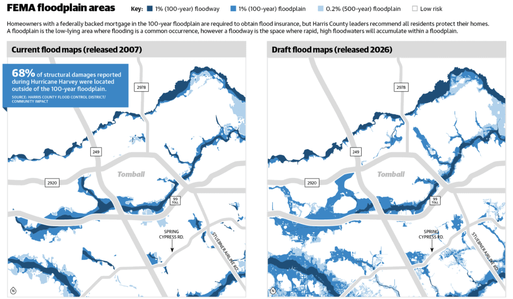
Harris County residents can now see preliminary Federal Emergency Management Agency map data through a new interactive dashboard from FEMA and the Harris County Flood Control District. The February draft reflects nearly two decades of change, as FEMA last released flood maps in 2007 using data from Tropical Storm Allison, per the agency’s website.
What you need to know
Per the data, the proposed changes would re-map the 100-year floodplain to include certain areas around FM 2920 and Telge Road, and near neighborhoods such as Willowcreek Ranch and Country Club Greens.
FEMA requires all property owners with a federally backed mortgage living in a 100-year floodplain—areas with a 1% annual chance of flooding—to obtain flood insurance through private insurers or the National Flood Insurance Program, known as NFIP.
Emily Woodell, HCFCD chief external affairs officer, said new insurance requirements won’t take effect until the map is finalized in two to three years. She said HCFCD doesn’t know the exact number of homes now in a floodplain, but there was a “significant expansion in the maps” driven by a 30% increase in rainfall rates.
As for cost, Houston-area insurance agent Jose Medrano said every property is unique, and the map alone no longer determines premiums. In 2023, FEMA implemented a new pricing system called Risk Rating 2.0 that uses factors such as home elevation, distance to flood sources and construction history to calculate quotes.
Another detail
Medrano said standard homeowners insurance does not cover flood-related damages.
“Flood insurance, what that covers is damage to your property if water comes from the ground up,” he said. “Regular home insurance is if the water comes in from the sky down.”
Residents can obtain flood insurance directly through FEMA or through its Write Your Own Program, which is a list of private companies that issue standardized policies regulated by the NFIP.
Zooming out
In addition to rainfall, development contributes to the increased flood risks seen in northwest Harris County, Medrano said.
New streets and buildings impact the flow of water, particularly in flat regions like Cypress and Katy.
One more thing
All Harris County residents are eligible for flood insurance through the NFIP, per HCFCD.
“Everyone in Harris County should have flood insurance,” Woodell said.
Next steps
HCFCD Executive Director Tina Petersen said the dashboard has been updated with the preliminary FEMA data. However, she cautioned against using the data formally as it is set to change.
Precinct 3 Commissioner Tom Ramsey said his concern was that residents who are purchasing homes without the updated floodplain maps could be purchasing homes within a floodplain.
Petersen said part of the decision to release the preliminary data was to educate the public.
Before you go
Woodell said Harris County is at the start of a long process to update the maps and, as a result, finalize insurance changes. Meetings will also be held so the public can submit feedback on the new maps, Petersen said.