The updated floodplain maps released in February are drafts and will not change insurance requirements or building standards until they're finalized in two to three years, according to the Harris County Flood Control District. (Community Impact staff)
It’s been more than two months since the Federal Emergency Management Agency and the Harris County Flood Control District released the long-awaited draft maps highlighting updated flood risks across the region. While the data is a work in progress, local homeowners are wondering how the changes will impact their bills.
The big picture
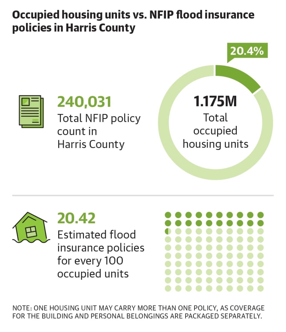
FEMA requires all property owners with a federally-backed mortgage living in a 100-year floodplain—areas with a 1% annual chance of flooding—to obtain flood insurance through private insurers or the National Flood Insurance Program, known as NFIP.
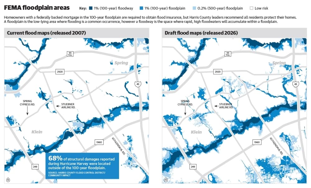
A before-and-after glimpse of the preliminary maps indicates more Spring and Klein homes fall within a high-risk flood zone, potentially impacting flood insurance requirements for certain residents. The February draft reflects nearly two decades of change, as FEMA last released flood maps in 2007 using data from Tropical Storm Allison, per the agency’s website.
Emily Woodell, HCFCD chief external affairs officer, said new insurance requirements won’t take effect until the map is finalized in two to three years. She said HCFCD doesn’t know the exact number of homes now in a floodplain, but there was a “significant expansion in the maps” driven by a 30% increase in rainfall rates.
“Our stance has always been and will always be that everyone in Harris County should have flood insurance no matter where you live,” she said in an email to Community Impact.
As for cost, Houston-area insurance agent Jose Medrano said every property is unique, and the map alone no longer determines premiums. In 2023, FEMA implemented a new pricing system called Risk Rating 2.0 that uses factors such as home elevation, distance to flood sources and construction history to calculate quotes.
A large majority of NFIP policyholders in Spring and Klein ZIP codes saw a $0-$10 increase to monthly premiums between 2024 and 2025 based on the Risk Rating 2.0 matrix, according to FEMA data. Most annual premium increases are capped at 18% per year, per the agency's website.
Another detail
While standard homeowners and renters insurance covers damages related to fire, wind, rain and hail, the policies do not cover flood-related losses, Medrano said.
“Flood insurance, what that covers is damage to your property if water comes from the ground up,” he said. “Regular home insurance is if the water comes in from the sky down.”
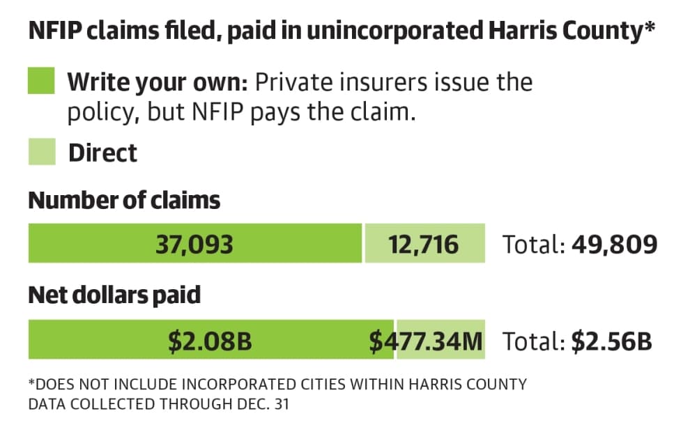
Residents can obtain flood insurance directly through FEMA or through its Write Your Own Program, which is a list of private companies that issue standardized policies regulated by the NFIP.
Source: National Flood Insurance Program/Community Impact
The cost
For those weighing the price tag of flood insurance, affordability concerns may tip the scale away from the additional coverage. Annual flood insurance premiums vary greatly for Harris County residents—anywhere from $500 to more than $1,000—according to FEMA data.
Tom Steinbacher, like many Houston-area residents, used Hurricane Harvey to determine if he needed flood insurance for his Klein-area home. He said homes down the street flooded during the 2018 storm, but water levels at his property never exceeded the yard.
Steinbacher said the extra coverage makes sense for residents in more flood-prone areas, but for his home he doesn’t consider it a necessity worth the cost.
“If I didn’t flood during Harvey, I cannot fathom a torrential downpour that would cause my house to flood,” he told Community Impact.
Medrano said residents living outside the 100-year floodplain may be eligible to purchase an NFIP policy at a lower rate. The NFIP also offers discounts for properties that are now mapped in a high-risk zone based on the updated data.
Standard flood insurance policies take 30 days to take effect, Medrano said, meaning those who add the coverage last minute before a heavy storm won’t be protected.
Source: National Flood Insurance Program/Community Impact
Zooming out
Medrano said in addition to rainfall, development contributes to the increased flood risks seen in northwest Harris County, as new streets and buildings change the flow of water, particularly in flat regions like Cypress and Katy.
The 2026 draft maps reflect updated terrain information, which combined with new rainfall patterns depict a more accurate picture of neighborhoods that are in a high-risk flood area, per the flood control district’s website. County officials clarified properties have not suddenly moved into a floodplain thanks to the maps—they had been high risk for several years, but the maps hadn’t reflected it.
Source: National Flood Insurance Program/Community Impact
Staying prepared
All Harris County residents are eligible to purchase flood insurance through the NFIP, according to the flood control district. Additionally, many private insurers not associated with FEMA’s program offer their own flood insurance policies, but coverage options vary by location and property.
Tips to kick off your flood insurance research:
Visit www.floodsmart.gov and enter details about your property to get a quote.
Compare potential changes to your flood zone by visiting www.maapnext.org and entering your address. Use the slide tool to view FEMA’s existing maps versus draft maps.
Woodell said Harris County is at the start of a long, federally regulated process to update the maps and, as a result, finalize insurance changes. In the meantime, she said residents should use the maps to make informed decisions about where to live, work and play.
As for how the updated data impacts local policy down the line, Woodell said Harris County’s 34 floodplain administrators representing governing entities across Greater Houston will be responsible for updating development standards and building regulations after the maps are finalized.
“The Flood Control District has no regulatory authority,” she said. “We are the technical team providing data and helping to ensure everyone is looking at the same information.”
Prepare your property for hurricane season (June 1-Nov. 30):
Research flood insurance policies.
Add your agent to your phone contacts, and email all important documents to your phone.
Take pictures or videos of each room in your home to make a home inventory.
Consider comprehensive auto coverage for your vehicle, which covers flood, hail, fire and wind damages.
Toughen the exterior of your home with window shutters and a wind-resistant garage door.
Prepare your yard by removing dead tree limbs and low-hanging branches.