
As New Braunfels continues to grow, one of the main tools used by the city to guide roadway planning is its thoroughfare plan, which saw its first major update Dec. 8.
The plan acts as a way for the city to build roads more efficiently as growth occurs, said Garry Ford, New Braunfels director of transportation and capital improvements.
“[The thoroughfare plan] sets the framework of our city that provides connectivity for vehicles, but also connectivity for emergency access,” Ford said. “Then, as development comes in, they start providing right-of-way dedication for that network.”
Digging deeper
The thoroughfare plan is a part of the city’s comprehensive planning efforts and serves as a blueprint for how major roads and connections should function as the community expands, Ford said.
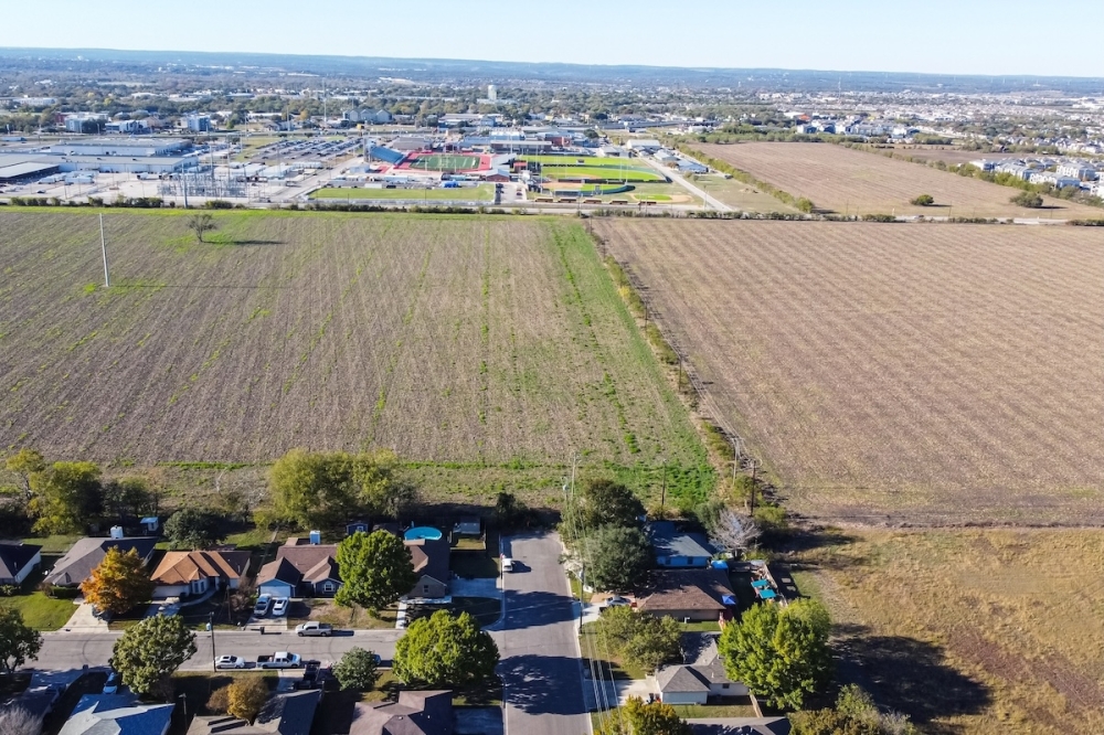
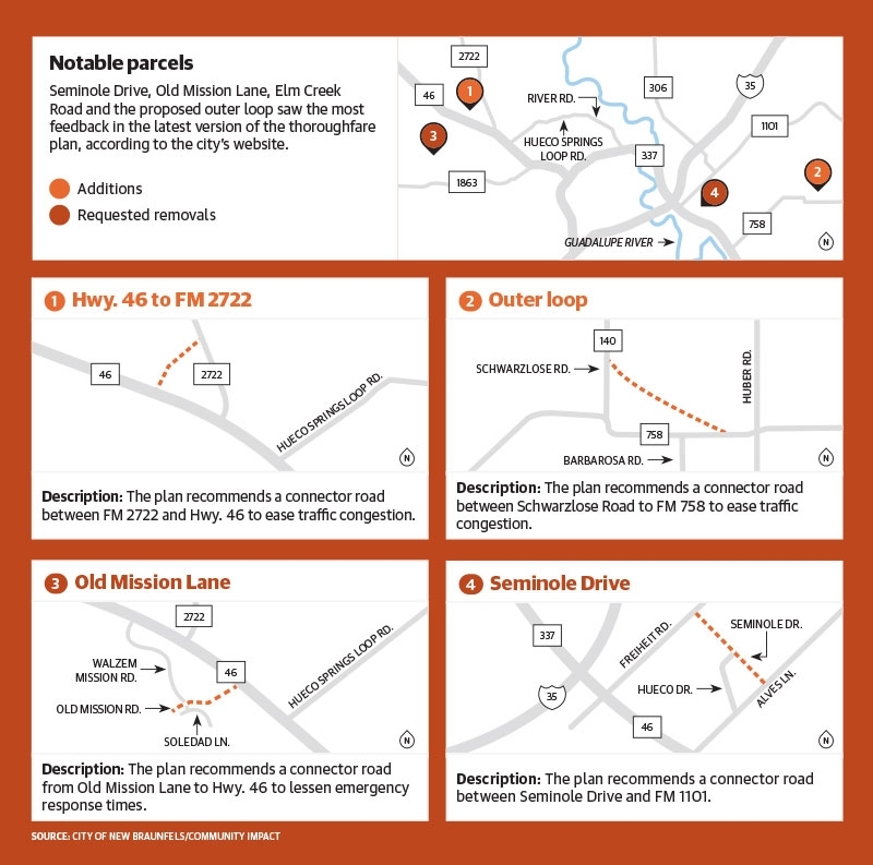
Rather than focusing on short-term construction projects, the plan looks decades ahead to identify where future roads are needed from a bird’s-eye view. The plan also explores how existing streets near Seminole Drive, Old Mission Lane, Elm Creek Road and River Oaks Drive could be widened or improved, and how traffic can move efficiently throughout the city, Ford said.
The plan is in coordination with state and regional transportation agencies, including Comal and Guadalupe counties, the Texas Department of Transportation and the Alamo Area Metropolitan Planning Organization. It maps out the importance of different types of roadways—such as principal arterials, minor arterials and collectors—each designed to serve different purposes in vehicle mobility, city staff said.
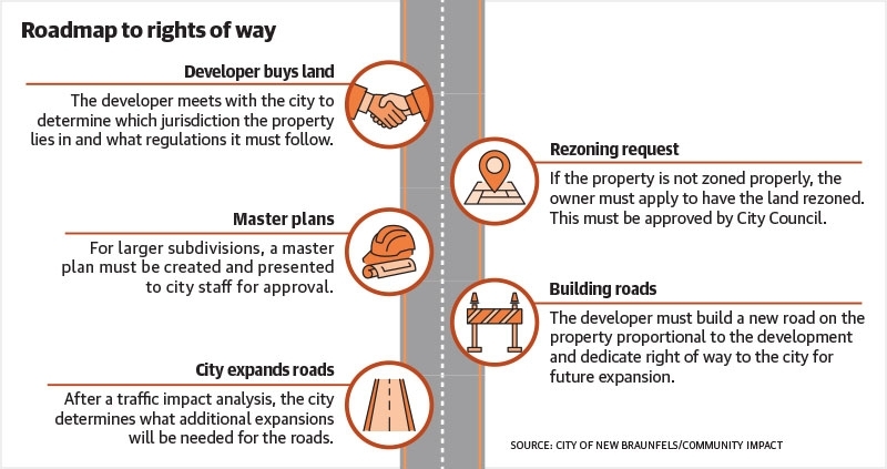
One of the main objectives of the thoroughfare plan is to preserve right of way for future transportation needs. ‘“Only when and if” development occurs can the city require dedication of land within developments or plan roadway improvements in locations identified on the map, Ford said.
“All it forces that builder to do is to coordinate with the other roads so that it makes sense and it’s efficient,” Ford said. “So we’re not going to be building roadways in the middle of someone’s farm, because if they don’t sell the farm, there’s no need for a roadway.”
How it works
Once land is bought or platted for development, the property owner must meet with the city to discuss the proposed project. The city will determine where the property lies—either within the city, the county or extraterritorial jurisdiction—and what regulations apply, Ford said.
The property owners must then ensure it is properly zoned, and if it is not, they must seek a zoning change, according to the city’s website.
For larger parcels or subdivisions, a master plan is required to identify all city-required improvements, such as roadways, drainage and wastewater infrastructure. A traffic impact analysis is also completed so city officials can determine if any other improvements are needed, Ford said.
Assessing the need
Beyond efficiency on the roadways, the thoroughfare plan takes into account response times for emergency services in the city. For the New Braunfels Fire Department, the plan acts as a “public safety” plan, Fire Chief Ruy Lozano said.
Roadways allow for emergency services to get to residences quickly, which could be the difference in saving a home from fire, Lozano said. He said if a thoroughfare plan isn’t designed when new growth occurs, then emergency responders are having to take older roads that are remote from new development.
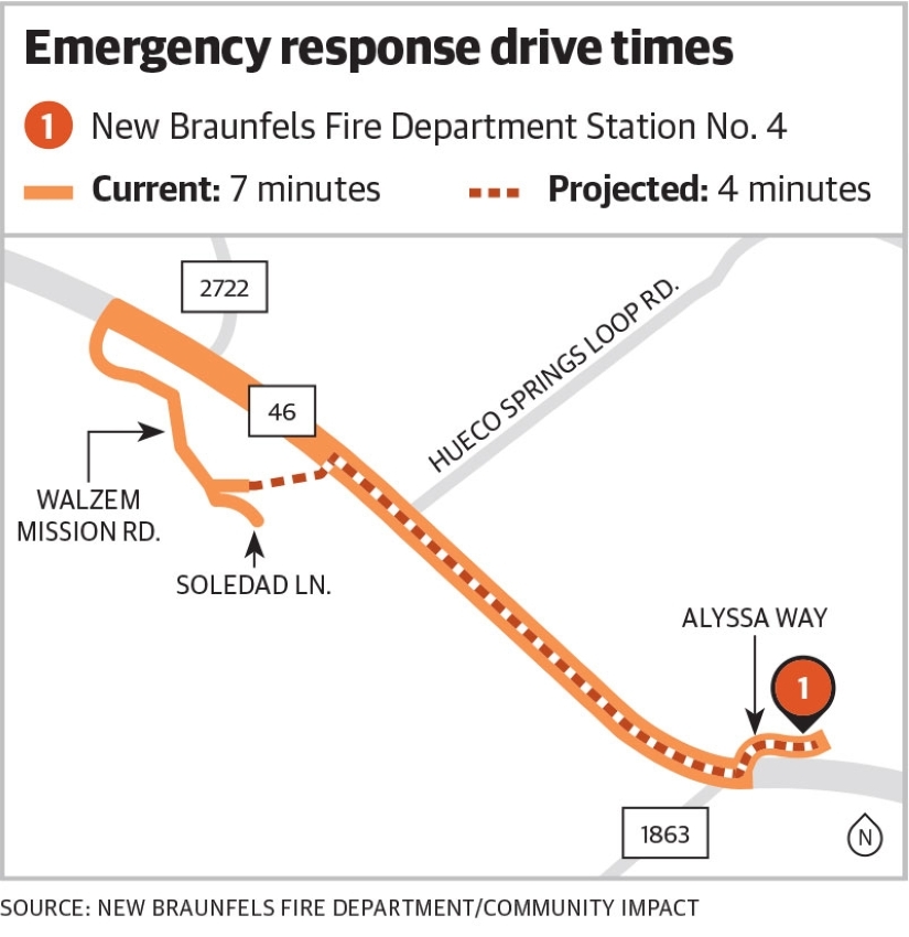
During a Nov. 4 City Council meeting, Lozano, as an example, showed a hypothetical response time from Fire Station No. 4 to the furthest point in Mission Hill Ranch—part of the thoroughfare plan. From the station to the location without the plan, the drive would be about 3.4 miles and take about seven minutes, according to the presentation.
However, if the extension within Mission Hills Ranch were to take place, it would cut the distance to 2.3 miles, with a drive time of four minutes, moving the department closer to the National Fire Protection Association’s standards of four-to-five-minute response times, he said.
What they’re saying
The city held several public meetings in the eight months leading up to the plan’s adoption, New Braunfels Deputy City Manager Jordan Matney said.
Four tracts of road were proposed for removal in an update to City Council on Nov. 4. Seminole Drive, Old Mission Lane, Countryside Drive and Pleasant Lane received the most feedback from community members who were worried about rights of way encroaching on their properties. Ultimately, city staff recommended that no parts of the plan be removed, according to the Dec. 8 presentation.
To be removed from the plan means that in those areas, when—and if—development occurs, developers would not be required to designate the right of way to the city, according to the presentation.
Going forward
Changes can be made to the now-adopted thoroughfare plan, but they will come as land is sold, bought and platted for development. Updates help ensure the plan remains a flexible guide rather than a fixed mandate, District 3 council member D. Lee Edwards said.
“At the end of the day, it’s a proposal," Edwards said.
More broadly, plan provides New Braunfels with a proactive framework for managing growth and transportation demand.
“[The thoroughfare plan] sets the framework of our city that provides connectivity for vehicles but also connectivity for emergency access,” Ford said. “Then, as development comes in, they start providing right-of-way dedication for that network.”