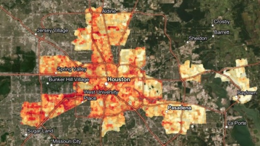
Researchers with the Houston Advanced Research Center, the city of Houston, Harris County Public Health and The Nature Conservancy of Texas published a map Jan. 5 displaying the range in temperatures collected by 84 volunteers throughout Houston and parts of Harris County on Aug. 7.
The Galleria area recorded the hottest temperature at 103 degrees Fahrenheit, differing significantly from the 86-degree temperature recorded in Channelview at the same time.
The study indicates that environmental factors such as tree cover and amount of paved surface area have the greatest effects on recorded temperatures.
“Science shows that there is real potential to reshape our built environment and cool our cities down where it’s needed most,” said Suzanne Scott, state director of The Nature Conservancy in Texas, in a news release.
To address these discrepancies, city leaders will consider adding coordinated tree planting, cooling centers and shade structures in high-heat areas, a news release stated.
“The data has identified Houston’s ‘hot spots’ and shows that some Houstonians are impacted by urban heat island effect more than others,” Mayor Sylvester Turner said in the release. “We will work with partners to target our cooling and health strategies toward these neighborhoods to better help Houstonians beat the heat.”
The study was conducted as a component of a larger effort called Heat Watch, led by climate research firm CAPA Strategies with funding from the National Oceanic and Atmospheric Administration's Climate Program Office. The Houston and Harris County-area study was also funded by Shell Oil Co. and Lowe’s Companies Inc.
View other U.S. cites' heat maps here.


