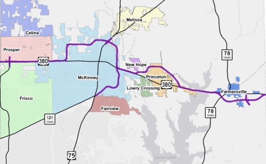
The Texas Department of Transportation, which is overseeing the project, recommended a bypass alignment for US 380 last May despite concerns raised by city and county officials.
This preferred alignment would start in Prosper along US 380’s current roadway and then run north between Ridge Road and Stonebridge Drive in McKinney, avoiding the Tucker Hill neighborhood. The alignment would then continue east along Bloomdale Road and move slightly north to connect with US 75 near Laud Howell Parkway. It would then reconnect with US 380 at Airport Drive. The proposed alignment would also connect US 380 to SH 121 west of the McKinney National Airport. The alignment would run south of New Hope, north of Princeton and south of Farmersville.
TxDOT’s recommended alignment is estimated to cost $2.597 billion, according to documents.
This alignment is expected to affect or displace at least 74 businesses and 90 residential properties, according to TxDOT’s presentation. In addition, the agency predicts roughly 220 acres of planned future development and 655 acres of environmental, watershed and parkland will also be affected.
TxDOT is recommending this alignment because it would offer the best east-west mobility in central Collin County, according to the presentation.
It will be another six to 10 years before construction starts on the nearly 33-mile roadway, and the project could take up to 20 years to complete, according to TxDOT officials.
Prior to turning dirt, TxDOT will divide the road into independent projects and prioritize them. Then, an environmental impact study will be conducted, and design schematics will start. TxDOT is in the final stages of hiring a consultant to initiate the environmental process in Collin County, TxDOT Public Information Officer Emily McCann said.
This environmental study phase is expected to start in 2020 and could take two to four years to complete, she said.
The environmental study will look at historic places, cemeteries and wetlands that might be affected by the alignment, according to TxDOT. During this phase, the agency will look at all viable options for an alignment in addition to the recommended route.
Though the study phase, the alignment could shift slightly from what was originally presented, according to TxDOT.
Right of way acquisitions will also start to take place but could take from three to five years to complete.
Residents will be invited to open houses and public meetings throughout the course of the process, but future meetings have not been scheduled yet, McCann said.


