Nathasha Collmann has lived in Steiner Ranch near Northwest Austin in an unincorporated area of Travis County for 21 years. She said she remembers the windy, hot day in September 2011 when 23 homes and 160 acres of land were destroyed by a wildfire.
When disaster strikes, emergency operations plans kick into gear, first responders deploy and emergency shelters open. But another plan, required for every U.S. jurisdiction by the Federal Emergency Management Agency, attempts to lessen the effect of natural disasters before they occur.
Although Travis County has not yet started its hazard mitigation plan update, which is required by FEMA every five years, Williamson County and the city of Austin recently conducted separate surveys seeking input from residents to better tailor their plans. Preliminary survey results show about half of the population in both Austin and Williamson County has experienced a natural disaster.
[polldaddy poll=9043865]On the day of the Steiner Ranch fire, Collmann said, she and her family went outside to tend to a section of their fence that had fallen following a strong wind gust. Then they noticed bits of ash floating through the air.
“The winds were just crazy,” she said. “You could smell something in the air; the air had a funny color to it.”
She said her son discovered a section of the neighborhood closer to RM 620 was burning, and everyone in the neighborhood was evacuating.
She and her family decided to get in the car and leave—it took them two hours to get out of the neighborhood, she said.
Stacy Moore-Guajardo, Travis County emergency management coordinator, said after the Steiner Ranch wildfire and a larger fire in Spicewood that burned nearly 7,000 acres, the county adopted its Community Wildfire Protection Plan.
The CWPP details areas highly susceptible to wildfires, many of which lie in western Travis County where developers have built neighborhoods with only one access road in or out of the community.
The county likely will use information from the CWPP in its 2017 hazard mitigation plan update, Moore-Guajardo said.
Floods, wildfires top hazard lists
 Moore-Guajardo said Travis County must submit its hazard mitigation plan update to FEMA by August 2017. Although the county will officially begin the update in 2016, officials have started discussing 2017-22 priorities, she said.
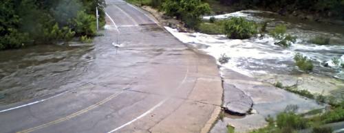
“Flooding is always going to be our No. 1 priority, right in line with wildfires,” she said. “We have [had] a lot of flood-related deaths.”
According to the Medical Examiner’s Office, Travis County experienced one flood-related death in 2012, six in 2013, one in 2014 and two as of July 2015.
“As much as you try to educate the community not to drive into high water, they just continue to do it. It’s just sad, and it’s frustrating,” Moore-Guajardo said. “And it’s preventable.”
Stacey Scheffel, Travis County flood plain administrator, said 146 square miles of Travis County lie within a flood plain.
Jarred Thomas, Williamson County emergency management coordinator and the Texas Colorado River Floodplain Coalition Region II representative, said the hazard mitigation plan allows the county to evaluate each hazard’s potential threat and prioritize projects to mitigate the threats.
Floods and wildfires are also the top two natural hazards in Williamson County, he said. Since the current plan was adopted, Tropical Storm Hermine in 2010 damaged 670 residences and businesses in Williamson County, and Memorial Day weekend floods in 2015 damaged more than 300 properties, Thomas said.
The county’s 2016-21 plan will provide an update on each action item in the current plan and recommend new projects.
Thomas said Williamson County must submit its new hazard mitigation plan to the state for review by January. The state, FEMA and Williamson County commissioners must approve the document.
Thomas said Williamson County’s updated plan would likely be available to the public by the end of 2016.
Austin prioritizes flooding
The city of Austin also ranks flooding as its No. 1 natural hazard, followed by wildfires, said Jacob Dirr, spokesperson for the city’s Office of Homeland Security and Emergency Management.
Erin Capps is vice president of operations at H20 Partners, an Austin consulting firm that developed the city’s last two hazard mitigation plans and is working on the most recent update.
Capps said Austin’s plan is independent from Travis County’s because it allows the city to incorporate more detail into its plan, but the two plans will have similar priorities.
Dirr said unincorporated Travis County contains a great deal of rural space; Austin has more urban development, which means more impervious cover, more stormwater runoff and potentially more flooding.
Capps said a planning team is determining what progress has been made on each of the 30 action items initiated in the 2010-15 plan. The updated plan will include a recommendation on whether the city should continue each action.

Prepare for the worst
After the 2011 wildfire Collmann started the Steiner Ranch Firewise Committee, which she chairs. She said the neighborhood has worked with Travis County and the local fire department to take action to mitigate wildfire hazards in Steiner Ranch, including educating residents and thinning brush from fence lines that back up to the Balcones Canyonland Preserve.
But participation from property owners has waned in the past four years, she said.
“We’re really struggling to continue to get people interested,” she said.
In Austin, 47.7 percent of those surveyed said they had already taken some action to make their properties more resistant to hazards.
To receive weather alerts by text message, visit https://wireless.capcog.org.