
For up-to-date information on current conditions, visit the Harris County Flood Warning System, which shows current rainfall amounts and alerts.
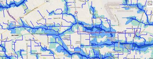
According to the HCFCD website, the tool illustrates floodplains delineated by the Federal Emergency Management Agency. The map does not show all potential flooding areas but illustrates 100-year flood areas, 500-year flood areas and areas where coastal flooding from a tropical storm or a hurricane is most likely.
The map is intended as an educational tool according to the HCFCD, and residents should refer to current reports for accurate information during a storm event.
The HCFCD website states that a 100-year flood is a flood that has a 1 percent chance of occurring in a given year. A 500-year flood has a 0.2 percent chance of flooding in a different year.
Some major roads that cross floodplains, according to the map, include:
- Hwy. 249 between Cypress Creek and Willow Creek
- Grand Parkway at Willow Creek north of Boudreaux Road
- Hwy. 290 near Cole Creek and White Oak Bayou between West 43rd Street and Jones Road
- Areas along Buffalo Bayou, including I-10 in Katy, 610 Loop and Hwy. 59
- Hwys. 59 and 90 and I-45 downtown at White Oak Bayou and Buffalo Bayou
- I-45 at Sims Byaou, Halls Bayou and Greens Bayou
- Hwy. 59 at the San Jacinto River
- Hwy. 90 at Lake Houston